Welcome to our Adventure!

Al and I are thrilled that you have found your way to our blog. We hope you enjoy reading our journal and viewing our photographs of the natural wonder of our United States of America. Let's hit the road together!
Homer, Alaska

Tuesday, June 25, 2013

Vistas Galore

We are finding here in Bar Harbor that when you have a day off, and the weather forecast is dry for several hours in a row, you jump on the opportunity to get outside and take a walk! Last week the day after our excursion to the Blue Hill Peninsula we had a decent morning forecast, so we packed up the pups and headed off to do the Beech Cliff Loop Trail, and then look for a few more caches here on the island.

Beech Cliff Loop Trail is a short 1 mile loop with beautiful views of Echo Lake and Frenchman's Bay out to the ocean. I know our walks have been on the shorter side this year, but Chelsea is getting up there, eleven years old now, and simply isn't up to long or strenuous walks. And it would break our hearts to leave her behind by herself, so we all go together and we pace ourselves to her :-).

On the way, though, first we stopped for a cache in the historic village of Somesville, the oldest settlement on Mount Desert Island, founded in 1761. Unfortunately, the little museum has very limited hours...

but the most photographed bridge in the State of Maine is always open!

across the street is a pretty little pond

which drops over a small dam with a fish ladder built on the side (so the alewives can get up into the calm waters for spawning)...

and flows into Somes Sound, the only fjord on the East Coast. Very pretty stop, and a successful caching venture.

On to the Beech Cliff Loop Trailhead.

The trail starts out in a dark forested area

with pine trees of all different sizes lining both sides of the trail. I love pine trees, but unfortunately the pine pollen is absolutely killing us..

Our typical hiking formation: Chelsea several feet behind Al....

Casey several feet ahead :-)!

Out of the woods, onto the cliffs, and what a view!

They really weren't kidding when they said the trail hugs the cliff edge

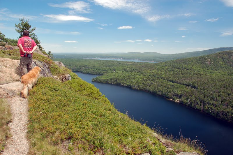
Looking down at Echo Lake. And yes Chelsea needs a boost to get up this "step"!

A view of the swimming beach at the end of Echo Lake, one of two swimming areas on the Island...the other being Sand Beach on the Park Loop Road.

The trail then loops back through the forest

and one last view before heading back down to the parking area.

With clouds rolling in, we stopped at Long Pond for another cache. This is a very popular area for canoeing and kayaking. We haven't gone yet, but they say if you go early in the morning its so peaceful and quiet and you can see all kinds of birds, particularly herons, eiders and loons.

Another cache led us to Seal Cove. We
 logged the find, and raced raindrops back to the truck.

We finished up the adventures for the day with lunch at a favorite spot in Southwest Harbor, The Little Notch Bakery. Panninis today, and of course some blueberry and raspberry danish for later. It did not disappoint :-).

We are getting busier now the closer we get to the Fourth of July holiday. We have been having some issues though, which have made things a bit more difficult. Our campground has an in-ground pool. They've had problems with the liner, and the company has been patching it to keep it going. Well, this year the patching is not holding, so when it was being prepared for the start of peak season, it actually ripped bad enough that it can no longer be repaired. So, we are currently waiting for a new liner to come in and be installed. In the meantime, the pool is not able to be used, so we are having to call a couple hundred reservations coming in over the next couple of weeks and inform the guests that the pool will be out of commission during their stay. You can imagine this is not sitting well with some of our guests! So its been a difficult few days making these calls, and helping guests with alternate options. 

We did have a nice night last Thursday with the other four workamper couples. We all got together after work at our "worker community site" (a small unusable area in between our rigs) and had a lobster bake dinner. We bought live lobsters at the lobster pound in Trenton, everyone brought a side dish, and the boiling was on! It was all delicious, and we have a really nice group of folks working this year...again. We have been so fortunate in that aspect, and it makes up for a myriad of smaller annoyances.

I have a ton of new pictures to go through from this last two days off, so bear with me, and my next posing will have pictures of seals, coastline and.......puffins!!Not to mention lots of company is arriving in the next week or so, so hopefully pictures of good times with good friends will be coming as well :-).

Tuesday, June 18, 2013

Blue Hill Caching

Our day off yesterday had a few hours of radiant sunshine, and we decided to take advantage of this by exploring the coastline just west of us in the area of Blue Hill. The Maine coastline has innumerable rocky coves, and the bumpy roads to traverse them :-). This excursion took us off Mount Desert Island north to Ellsworth, then south again along the coastline opposite from the west coast of Acadia.


View Larger Map

We find that going on a geocaching hunt lands us in some of the "off the beaten path" areas, so I pored over the geocache map of the area, and plotted a loop course of caches to try and find. It also makes us drive slower so we see more, and we get out of the truck a lot which makes the dogs happy :-)

First stop was Union River Bay boat launch in Surry. Surry is a tiny town, and without knowing there is a cache here, you would never think to turn down this little side street. A very peaceful spot with small waterfalls flowing down from the left hand side.

There are wildflowers everywhere at the moment.

Another cache spot in Surry, with scores of wild lupines along the river shore.

Newbury Neck Beach area looked very popular for swimming. This is the far, rocky end, but there was a sandier area. There were a lot of people there, though, and I knew if it were me, I wouldn't want pictures of myself in a bathing suit on the internet! :-)

Tiny lobster shack just off the beach. Nice place for a quick seafood lunch!

Another cache was found at the Town Park in Blue Hill. Blue Hill is another really cute seaside town with a wonderful waterfront park. Lots of picnic tables set up, a nice playground for the kids, and a set of stairs leading down to the beach area. The tide is down in this pictures, so the islands in Blue Hill harbor are quite prominent. Again, stealth was required for the cache as there were several muggles in the area :-)

Peaceful scene at Blue Hills Falls. There are two caches here, a regular cache and an "earth cache". An earth cache is not a physical cache, but one that has you observe and investigate some sort of natural feature that you answer questions about to claim your cache. This one was Blue Hill Tidal Falls.

The side going out to sea....

the side going to the Salt Pond.

"Tides passing in and out over the shallow bottom ledge under the bridge into Salt Pond in Blue Hill, Maine, create an impressive reversing waterfall effect that is very popular with whitewater boaters.
The tremendous tides cause the periodic rises and falls of the ocean in this area. Tides are caused by the gravitational interaction between the Earth and the Moon. The moon’s gravitational attraction causes the oceans to bulge toward the moon with another bulge occurring on the opposite side. When this bulge is coupled with the shape of the Gulf of Maine the tides become extreme.   Since the earth is rotating while this is happening, two large tide events happen each day.The reversing salt-water falls occurs under the bridge on Route 175 near Carter Point in Blue Hill. This 100 meter long set of falls is formed when the water rushes through a 20-meter gap between the ledges on both sides of the bridge.  As the salt water passes over jutting rocks under the bridge it causes the "waterfalls" effect.  The reversing falls actually are rapids, which are caused by large boulders and ledges in a narrow passage of water. The boulders and ledges, in addition to the narrow passageway between the bridge cement structures form a bottleneck, causing a rise in the depth of water on the neap side of the falls.  As the tidal current slows, the roar of the water gradually diminishes until at slack tide, for a short period of time, the water under the bridge is like a mirror.  Gradually, the direction of the water changes, the seaweed is swept in the opposite direction, and before you realize it ripples appear with the waves growing in size quickly. Remember that normally that the water flow to the ocean. At low tide, the Salt Pond empty into the sea under the bridge in a waterfall or rapid. As the tide rises above the falls, the seawater forces its way against the waters flow. The rapids slow to a stop for a short period of time giving the appearance that the falls have reversed.  This process repeats itself twice a day.  Because the water is constantly churning things up at the Reversing Falls it often attracts seals and eagle due to the waters provide abundant food for the animals, that makes visiting this earthcache a special treat." (source: Geocache description CG17X1E).
We determined the best time to see the white water was at low tide, when the water is rushing over the rocks to create the falls. We were there at quite possibly the worst time, exactly in between high and low tide...of course! But you could see the water rushing into the Salt Pond, but no wildlife beyond the gulls were in evidence.
Another lobster boat pulling pots, with the obligatory gathering of gulls behind it.

Our last cache attempt of the day ended in a "no find'...hate those! The spot is beautiful, and the tip of Naskeag Point. There's a small memorial here in honor of a Revolutionary War battle that occurred here in 1778.  Unfortunately, the co-ordinates were leading straight into a dense area of very thorny shrubs, and between not wanting to get shredded up by the thorns and the impending thunderstorm about to arrive, we gave up on this find. 

These look like brand new lobster pot buoys to me, the paint job is so shiny.

As we could see the storm front moving in quickly, it was time to end our caching for the day. The skies opened up in a wicked downpour shortly after we returned to the truck. We did find six, though, so it was a pretty good day, and we found some pretty little coves and towns along the way. All in all, a successful day off!

Saturday, June 15, 2013

Need I Say More?

Beautiful night on the Harbor...

Dining room on the dock....

Mile high fried shrimp....

fresh steamers....

Down East Lobster bake!

Friday, June 14, 2013

Campobello Natural Area

After getting our fill of history at the Visitor's Center in The Roosevelt Campobello International Park, it was time for some lunch and then we would set out to explore the 2800 acre natural area of the park. There are only two eateries on the island, and not wanting to cross the border back into Lubec, we drove the short distance to Wilson's Beach and found the Family Fisheries Restaurant and Takeout.

We checked out the menu at the takeout window, and before I made my decision on which sandwich to have, I asked the pleasant young lady at the window what the "Toll House Delight" is. A warm toll house cookie topped with a sundae...well all righty then, I'll have a grilled cheese sandwich, no fries or chips, and the Delight please!
Looks good doesn't it :-)!

Ok, so it was then time to work some of those toll house calories off! Campobello Island has a significant portion of land parcelled into two parks, the Roosevelt Campobello International Park and Herring Cove Provincial Park. Directly across from the Visitor Center is Glensevern Road, which is the dividing point between the two parks. The park roads are former carriage roads that are now narrow gravel roads, leading you to the points of interest throughout the park. We had several geocaching locations to check out, so off we went. We've found quite often that geocaching has led us to some beautiful locations, and today did not disappoint :-).

Our first spot was the boardwalk at Eagle Hill Bog. This is an interpretive nature walk, where you picked up a brochure at the trailhead and signposts marked special points of interest. It leads to a ridge that has a beautiful overlook...and a cache!

It's too early for many of the flowering plants on the tour, but we did see these pitcher plants, a carnivorous plant. The water collects in the "pitcher", luring insects down to drink. They are then trapped by the leaves folding down, like a venus flytrap. Cool!

Once across the bog, there's a forest trail up to the ridge.

Tree-top view

These are larch pines...they lose their needles in the winter. I couldn't believe how soft theses needles are.

The next stop was Raccoon Beach...to the left....

and to the right.

Liberty Point is on the south end of the island, and has three observation platforms looking in different directions.

This is Sugar Loaf Rock....can anyone see anything in this rock?? Kudos to the first one who guesses one of the two images said to be seen in it.

An iconic picture of Maine....love the birds flocking behind the lobster boat!

Cranberry Point

Last cache of the day at Upper Duck Pond

Gentle swells swirling onto the shores of Upper Duck Pond.

There are 7.7 miles of these old carriage roads, leading to over 8 miles of walking trails. It was such a calm, peaceful place, I can definitely see how it appealed to FDR and his family as a retreat away from the bustling urban centers. It was a very nice day, with a good history lesson, peaceful walks, and five caches found! It was worth the 2 hour drive each way for sure.