Welcome to our Adventure!

Al and I are thrilled that you have found your way to our blog. We hope you enjoy reading our journal and viewing our photographs of the natural wonder of our United States of America. Let's hit the road together!
Homer, Alaska

Monday, September 30, 2013

A Tragic Day for Mount Princeton, Colorado

Late breaking news out of our former work area from last summer was brought to our attention earlier this evening. Sadly, it has been confirmed that 5 hikers have been killed and a sixth injured at a rockslide at Agnes Vaille Falls. This short hike was our first hike in the area, and was also our last. I had never posted pictures of it, as I was busy with getting ready to leave at the time.

Agnes Vaille Falls

We were looking for a geocache at the falls, and after much searching, we did find it. The search did lead us up into the rock piles.

I absolutely shudder to think of this wall of rock crashing down upon us!

Prayers for the family and friends of these poor people.


Winding Down and Around

Our days are winding down here at Mount Desert Narrows. Two weeks left. I feel as if I've left so much un-done. The weather has been partially to blame, it really wasn't an extremely nice summer in this area of the country. It has been very wet, especially on our days off! It is what it is, however, and as we've had shorter days at work the past month, we have done a bit of exploring in Acadia.

The Carriage Roads of Acadia is a feature I have not yet written about. Sherry has written a great post about them here, so why re-invent the perfect wheel when she has done such a good job explaining :-)?. When our work day started ending at 4PM, it was time to get out and start exploring the carriage roads as best we could, of course at Chelsea's pace!

The carriage roads are America's best example of broken-stone roads commonly used at the turn of the 20th century. They are true roads, approximately 16 feet wide, constructed with methods that required much hand labor. Road crews quarried island granite for road material and bridge facing.

Speaking of bridges, there are 17 stone-faced bridges, each unique in design spanning streams, waterfalls, roads and cliffsides. This is Hemlock Bridge.

Waterfall bridge, with a very tiny trickle in the background. It had actually been dry for a couple of weeks when we took the walk here :-).

The bridges are steel-reinforced concrete, but the use of native stone for the facing gives them their natural appearance. Over time, the stone cutters became very skilled, and were asked by Rockefeller to not cut the facing too perfectly, losing the rustic look!

Casey always enjoys his walks.

Large blocks of granite line the roads serving as guardrails. Cut roughly and set irregularly, the coping stones add to the rustic feel of the roads. They are affectionately known as "Rockefeller's teeth".

The roads were aligned to follow the contours of the land to preserve the line of hillsides and save as many trees as possible.

The roads are also graded so they were not too steep or too sharply curved for horse drawn carriages. That was the original intent behind the carriage roads; Rockefeller was very disturbed by the advent of the automobile intruding upon the serene beauty of the Island. In an effort to keep the automobile as far away as possible, he had these carriage roads built so the wealthy "cottagers" would be able to continue their travels across the island by carriage.

I always like this view of the "Bubbles" across Jordan Pond.

Cobblestone Bridge, the only bridge that is completely faced in cobblestones.

The workmanship is beautiful.

There are also two Gate Lodges in the system. This one is at Jordan Pond, the entrance to many of the carriage roads. 

All in all there are over 45 miles of these rustic carriage roads, the gift of John D. Rockefeller Jr. and family. His construction efforts from 1913 to 1940 resulted in roads with sweeping vistas and close-up views of the landscape that endure today. Each year, the Friends of Acadia contibutes more than $200,000.00 for carriage road maintenance. Their use is still strictly maintained for pedestrian, biker, and horseback rider use only. We have found them to be wildly popular with the visitors here at Acadia. Even though we always have other people using the roads, though, the sense of quiet and peacefulness is always there.It has been a wonderful place to take our afternoon walks!

Saturday, September 21, 2013

More Nova Scotia

After a quiet night at Ingonish Chalets (where we stayed in a pet-friendly cabin), we had a hearty breakfast at the Bean Barn Cafe. I short aside here, I have started using TripAdvisor to help make decisions on lodging, campgrounds, restaurants and attractions. I have found it most helpful. It was an invaluable resource for this trip, and we enjoyed every place we stayed and ate during our stay. Try it, you may find it helpful as well :-)

Our first destination this morning was a short backtrack to MaryAnn's Falls. This was another drive-in site, down a much longer, 7 kilometer dirt/gravel road, with a short hike at the end. It was extremely bumpy, we almost felt like we were back in Colorado for a few minutes :-). What a beautiful area, though, well-worth the side trip.

Top of the falls...it looked like the road used to come down further, and over the bridge that I was on taking this picture, but from the looks of the bridge it isn't safe to drive over it any longer! So the parking area was made about 1/4 mile back, and you walk the rest of the way.

View from the base. A stairway leads to a viewing platform, and then you can clamber down the rocks to the base of the falls.

The water then flows down through this beautiful canyon.

Exploring a trail further down, we found this viewing area above the falls, which is even nicer. It's good to see where unknown trails lead :-).

Back down the bumpy gravel road, we headed to our hiking destination for the day: Middle Head Peninsula Trail.
Map - Middle Head
 The guide says it is a 2.4 mile combined loop/ out and back trail, but our gps tracker clocked it at closer to three miles. We took water and planned to go slow, at Chelsea's pace, and see if she could manage the entire distance. 

The trail alternated between wooded...

and open areas.

Views of Cape Smokey across the water

You really shouldn't go close to the edge, see how sheer the drop-off is?

The path veered to the edge of the peninsula, back into the woods, back and forth several times.

We made it to the point, and sat for awhile for a well-deserved rest. Bonus points for the eagle that flew by!

Heading back to the parking area. The round-trip took us about two hours going nice and slow.

After a delicious lunch at the Main Street Restaurant and Bakery, we continued down the coastline, doing a little geocaching and stopping at a few overlooks. The weather started going downhill from lunchtime on, and was becoming quite cloudy. By the time we arrived in the cute little town of Baddeck, on the shore of the Bras d'Or Lake, it was spitting rain on and off and the fog had the great views of the lake socked in. We had a light dinner at the local pizza place, Tom's, as we had had a big lunch, and turned in early at our chalet at the Silver Dart Lodge. In what turned out to be a harbinger of bad things, Al said he was extremely tired and just wanted to turn in early.

The next morning he seemed to feel better, and we headed off Cape Breton Island towards New Brunswick. We were planning on visiting Hopewell Rocks on the Bay of Fundy. This is a fascinating area where the tides have their most dramatic change, with 40+ feet of difference between high and low tide. The Hopewell Rocks, also called the flowerpot rocks, are a unique geologic formation caused by the eroding power of the water. 

Along the way we had seen signs for the Bluefin Tuna Interpretive Center in Ballantyne's Cove, on the Northumberland coast of Nova Scotia. As Al has had many a happy day fishing for bluefin tuna, we thought it would be a pleasant diversion for the drive.

Nova Scotia boasts that it has the largest concentration of bluefin tuna in the world, and the world's largest bluefin tuna caught was recorded out of this marina, at 1496 pounds, in 1979

Unfortunately, the Center was closed, so all we have is a picture of the outside :-(.

The obligatory lighthouse picture, this one the Cape George Lighthouse, the third one on this site with the original built in 1861. 

Our original plan was to see the Hopewell Rocks Wednesday night at high tide when we arrived, then return in the morning at low tide when you can actually walk on the ocean floor at the base of the rocks. We missed high tide by about an hour, and the tide had already receded by about 10 feet. It was also quite foggy! We settled in our cabin at Broadleaf Ranch, and went to have some dinner. It was at that point that Al informed me he was pretty sure he was coming down with a "bug", and felt that the next morning was not going to be very good :-(. His diagnosis proved to be spot on, and I ended up getting us packed up and headed straight back to Bar Harbor rather than visiting Hopewell Rocks again. 

And that's pretty much where we've been at since then. He was feeling pretty lousy for a few days, and we did take a trip to the Trenton Clinic just to make sure nothing more serious was going on. The doctor is fairly certain it's a virus, and it will take some time before he's feeling up to par. Improvement is slowly occurring, and he is back to work again, although its a good thing things have slowed down from the peak season. We still have quite a few guests coming and going, but it's a more relaxed pace. It is still busy in town, as there are several cruise ships in port each day this time of year. 

Hitch itch is starting to set in! We have less than four weeks left to go before we leave, and we have our start date of October 28 for Amazon. We are starting to firm up plans for our week long visit with family and friends back on Long Island. And we're also thinking about where we're going to be next summer, and lining up interviews. Plus, the last few items on our list of things to see and do before we leave the area. A busy time,all in all. Until next time...have a great day!!


Tuesday, September 17, 2013

Nova Scotia...Continued!

Ok, so I pretty much blew it by posting at lunchtime instead of saving it at lunchtime. I just get myself in trouble by doing things piece meal I guess. So, anyway...as I was saying.....

The Cabot Trail is one of the world's most scenic highways. It was completed in 1932, and is considered an engineering marvel, 185 miles of rolling highway, dipping up and down, skimming over the heights of the famous Cape Breton Highlands National Park. But first, as we left Port Hawkesbury, we picked up the Ceilidh (kay-lee) Trail and followed the coastline up to Margaree Harbor, where the road turned into the Cabot Trail.

The Celtic culture is very strong in Cape Breton, where Gaelic is still taught in the schools. A "ceileidh" is a traditional Gaelic social gathering  which usually involves music and dancing. The road takes you through several small towns along the way, and several ceileidhs were advertised at various public buildings for different nights of the week. It would have been interesting to go see one, but there wasn't one in the area we ended up staying. 

We also had downloaded several geocaches located on the island...always fun to grab a new state or province "souvenir"...your first find in a state or province loads a "souvenir tag" in the program. It's fun to collect new souvenirs.

Our first cache in Cape Breton was here at Mabou Harbour. The black pots in the harbour are black mussel sets....it's almost like lobster pots, except no traps. There's ropes hanging down from the buoy, and the mussels attach themselves to the rope. Harvesting is a simple matter of pulling up the rope and extracting the mussels off of it. 

Aren't old barns just so picturesque?

There's a day use beach at the entrance to Port Hood, so we stopped for a walk down the boardwalk to the beach.

Down the boardwalk to the beach

Next stop was the beach in Inverness

Piping plovers ( an endangered species) running through the surf. We have them back on Long Island, where we used to live. They are protected there, but are not popular as many prime sections of beach are cordoned off in the height of the summer while they are nesting. A few years ago our Fourth of July fireworks exhibits had to be moved to Labor Day weekend as a nesting couple had set up home within a few feet of the set-up zone. They have since come back every year, so now there is Labor day fireworks!

More bird life along the route...stunning.

I really liked the town entrance signs.

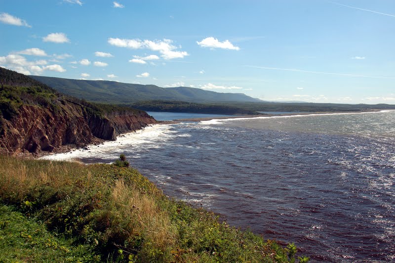
A fabulous view at the first overlook. There are over twenty overlooks along the highway, all with spectacular views. The Cabot Trail runs approximately 300 kilometers, linking previously isolated fishing villages. It was completed in 1932.

We stopped and had lunch in the beautiful village of Cheticamp, and I browsed the crafts at the Coopertive Artisanale. Cheticamp is the rug hooking capital of the world, and I enjoyed looking at the (expensive) pieces in the shop. I see you can order a kit online to try your hand at it...maybe?
Then it was on the the Cape Breton Highlands National Park Visitors Center to purchase our entrance pass and find a map of the park. I couldn't believe how fast the day was slipping by and I wasn't even half-way to my destination stop for the night!

As part of the attraction of the drive is the highway itself, there will be a few pictures through the windshield.


This was one of the scenic overlooks. We pulled in and I thought, oh there's not much here to take a picture of, it goes around a curve...then I looked back! I do hate it when the sun is at the COMPLETELY wrong angle for photos, but I did the best I could to block the glare.


Pillar Rock on a windy windy day

Calm waters in the sheltered cove...but there are some ripples!

A beautiful picnic area at Le Bloc...not today though, your food would blow away!

The highway dipsy-doodles along the coastline

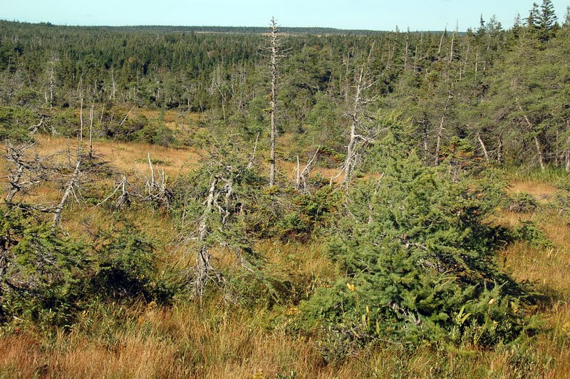
We stopped at a short hiking area called The Bog. It  has a boardwalk all through the boggy area with interpretive signs talking about the habitat and it's inhabitants. What a great place for moose to hang out wouldn't you think?? We had our eyes peeled...

wonderful heath area for the to roam...we did see the sleeping indentations they had made, although Al says the rangers probably come out and make them just so us tourists can get excited :-). 

A last view, without moose, as we headed back to the truck...but wait!!!

a quarter mile down the road, around a curve, there she is! Again, taking pictures right into the sun, but I cleaned it up as best as I could.

We sat for quite awhile watching her. She was quite unconcerned about us being there. We finally bid "adieu" to her and carried on down the road.


The topography of Cape Breton Island's coastline reminded us strongly of the beauty of Hawaii.This is Fishing Cove, a former isolated fishing village. It has been abandoned, but one is able to hike down to the coast and tent camp on the shores...all primitive, of course.

The highway curves around the tip of the north end of the island, across the highland plateau, and heads east to the Atlantic Ocean side of the island.

We followed a rough gravel road about 4 kilometers to beautiful Beulach Ban Waterfalls. 

As the sun slowly dropped in the west, we made it to the east coast, and here the coastline changed radically to the granite rocks just like the Maine coast here in Acadia.

As we made our way to our cabin for the night in Ingonish, a view of the Middlehead Peninsula with Cape Smokey in the background greeted us. Tomorrow's plans include a hike to the point of Middlehead, before continuing down to the town of Baddeck. And that will be the story for the next installment, as this has already gotten pretty long :-).