Those who know me, know that I am an East Coast girl. Born and raised on Eastern Long Island, NY, I have lived there for the first 49 years of my life. Those who know me also know that our only vacation time each year was exclusively two weeks in the month of February. My very first National Park was actually Volcanoes National Park, on the Big Island of Hawaii...you can't really get much further from New York to visit a National Park. For many, many, way too many years, this was my one and only National Park that I ever visited. Sad. Living in the Northeast did limit our possibilities, though. We finally did visit Acadia National Park three years ago, and loved it. Far too short a time there, though, as we spent our four-day anniversary trip there, and driving back and forth took up two of those days!
So you can imagine the excitement I feel over the wealth of National Parks we are now amongst, out here in the west, and at a time of year that is wonderful to visit...February was not so good! Mesa Verde National Park has always fascinated me since history class way back, longer than I care to mention :-). So it was with a sense of anticipation that I planned this adventure when our work schedules revealed we had three days off in a row just before Memorial Day weekend. The only downside to visiting the park now was that the Wetherill Mesa was not opened to visitors yet, but the upside was a reduced entry fee,as well as fewer visitors :-).
Wednesday we dropped the dogs off at their daycare center, Happy Hounds and Fat Cats (love the name), in Durango, and headed west to the park entrance. It was a 35 minute drive just to the entrance where we paid our fee to enter. From there, it is another 15 miles to the Far View Visitor Center. 15 very windey, beautiful, switch-backing, jaw-dropping miles. Its been estimated it takes an average driver approximately one hour to make the drive; it took us almost two! The road is fully paved, and easy to drive, with care of course, but we had to stop at every turnout to take in the view as well as read the history boards.
Mesa Verde as seen from the park entrance.
At Mesa Verde, Spanish for "green table", multi-storied cliff dwellings fill the rock-cliff alcoves that rise 2,000 feet above the Montezuma Valley. What is amazing to me is, looking at this massive formation, it looks like a huge, solid, impenetrable hunk of rock. But there are canyons running throughout the structure, extremely deep, and I wonder what brought these people to this spot. How on earth did they stand at the bottom, and say "we should go up there, and make our homes up there". Completely baffling to me. Anyway, these cliff dwellings cluster in canyons that slice the mesa into narrow tablelands. Between the cliff dwellings and the village remains located on the mesa top, archaeologists have located more than 4800 archaeological sites, 600 of which are cliff dwellings, dating from about A.D. 550 to 1300.
Our major stop on the way to Far View Visitor Center was called Park Point. Park Point is the highest elevation on the Mesa, and offers an unobstructed 360 degree panoramic view of the area. Unfortunately, due to atmospheric conditions, namely air pollution (creating a haze all the time) compounded with smoke haze from the fires burning to the south, and very windy conditions causing a lot of sand and debris in the air, the visibility was not as good as it should have been. It was still outstanding, though.

View to the west, Sleeping Ute Mountain on the left hand side. Today, the Ute Mountain Indian Reservation borders the park on three sides. One Ute legend depicts this formation as one of their gods who, at some remote time, became angered with his people, gathered all the rain clouds together in his pockets and laid down on his back and went to sleep. It is said that when the clouds are hanging about the peaks as they often do in times of a storm, that the clouds are slipping out of the rain god's pockets....There is further belief that the god will arise some day to lead the Ute Indians.

Part of the original horse/mule trail leading up to the Mesa. In January of 1905, as Congress deliberated the proposal to establish Mesa Verde as a National Park, its attention focused on the magnificent view seen from this point. In reference to the trail that at that time left the Mancos-Cortez highway, the 58th Congress stated, "This backbone or ridge is rolling in outline and from the highest hill over which the trail runs is one of the grandest and most extensive views in the country".

Wildfire is always a threat at Mesa Verde, and major wildfires have struck the park 7 times. Of these fires, the most devastating were the Bircher and Pony Fires of 2000, which together burned more than 29,000 acres. The Bircher Fire began July 20, 2000 when lightning struck the Bircher farm just east of Mesa Verde. The fire sped westward into the park, and in three days had blown out of control. Flames surrounded Park Point, and the historic fire lookout tower there was saved only by a wrapping of fire-resistant material. 12 years later, the damage is still here, in the eerie bare bones of the trees, bleached white, and the new growth underneath.
We finally made it to Far View Visitor's Center, where we purchased tickets for two ranger led tours into the archaeological sites of Cliff Palace and Balcony House. Realizing that it was another 5 miles to the Chapin Mesa complex, and once in the two loop drives it would be a ways back to the cafeteria for lunch, we opted to have an early lunch, and do our tours in the afternoon. Each tour is approximately an hour long, and one runs each hour and the other on the half hour. So we gave ourselves enough time to have lunch, and drive the Mesa Top Loop Road before our first tour at 1:30. We opted to have lunch right at the Far View Visitor's Center cafe, where we had their specialty item, Navajo Tacos. The staff there was very friendly, and we were glad to have taken their recommendation, as the tacos were very tasty. In retrospect, though, we would probably pack our own lunch next time, and eat at a picnic site as it would have given us more time to visit some areas we didn't get to.
The Mesa Top Loop Road is a six mile loop, and takes us on an overall discovery of the Ancestral Puebloans who came here around A.D. 550 to make a life for themselves. Through a series 12 stops we are
shown the full range of architecture at Mesa verde, from the earliest pithouses to the latest cliff dwellings. We see the progression of the homes and religious structures of the Ancestral Puebloans (often referred to as Anasazi) who lived here for more than six centuries, from about A.D. 550 until 1300. Ten excavated sites and a number of cliff dwellings are visible. I find it fascinating that we have something this old so well preserved in the United States! The views are awesome up here as well!
One of the oldest dwellings found, a pithouse. A.D.550 to 600. These are modest dwellings, shallow pits dug into the top of the mesa, covered with pole and mud roofs and walls, with entrances through the roofs.
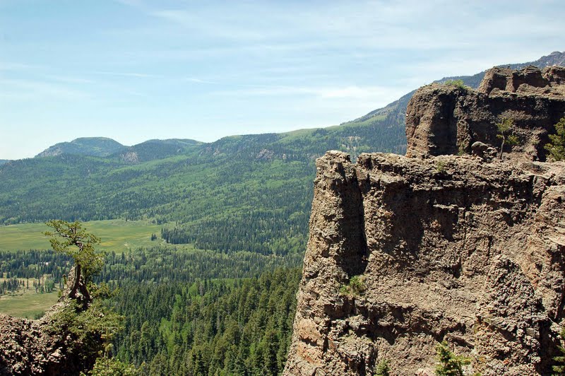
A magnificent view of the canyon from the rim of the mesa.
Mesa Top Sites A.D.900-1100. Buildings are becoming more sophisticated, and "kivas" are making an appearance now. Their significance is unknown, although most theories revolve around them being of religious significance.
Square Tower House. This site is not open to the public, but an overlook has been provided at the end of a short walk. A.D.1200-1300. The name comes from the beautiful four story high structure still standing against the curving back of the alcove. This site has been a treasure trove of artifacts for archaeologists. Square Tower House is representative of the last phase of building at Mesa Verde, but there are signs of much earlier habitation in pithouses under this alcove.
A close-up of the four story square tower. Simply beautiful.
A view inside the Sun Temple, A.D.1250, a fascinating structure believed to have been constructed purely for worship.
My favorite view...I love the way the mesa tops seemed to be geometrically positioned.
At last...a beautiful view of Cliff Palace, the site of our first ranger-led tour into the site.It is unbelievable to me how these dwellings have been built into the sides of a cliff...whatever possessed these people to do this? How on earth did they get down there??


Inside Cliff Palace. It is 120 feet below the top of the mesa. Recent studies have shown that there are 150 rooms, 23 kivas, and approximately 100 people inhabited it at any one time. It is thought that Cliff Palace was a social, administrative site with high ceremonial usage. Construction: "Sandstone, mortar and wooden beams were the three primary construction materials for the cliff dwellings. The Ancestral Puebloans shaped each sandstone block using harder stones collected from nearby river beds. The mortar between the blocks is a mixture of local soil, water and ash. Fitted in the mortar are tiny pieces of stone called "chinking." Chinking stones filled the gaps within the mortar and added structural stability to the walls. Over the surface of many walls, the people decorated with earthen plasters of pink, brown, red, yellow, or white -- the first things to erode with time."
Looking at the windows and doorways, and noting that they are so small, we wondered about the size of the occupants. An average man was about 5'4" to 5'5" (163cm) tall, while an average woman was 5' to 5'1" (152cm). If you compare them with European people of the same time period, they would have been about the same size. Compared with today, the Ancestral Puebloan's average life span was relatively short, due, in part, to the high infant mortality rate. Most people lived an average of 32-34 years, however some people did live into their 50s and 60s. Approximately 50% of the children died before they reached the age of five. I am not surprised by this, just look at the step out their front doors...its a dilly! I wonder how many children simply fell off the edge?!
Cliff House was an awesome experience, as was the exit....climbing five, 8-10 foot (2.6-3m) ladders on a 100 foot (30m) vertical climb. Um, no, I did NOT look down as I was climbing up.
Next up was our tour of Balcony House, another ranger-led tour of a beautifully preserved site. I must say here, that even though we had about 50 folks on each tour, the rangers were very good, reminding folks not to touch anything, lean on anything, and tried to impart that these areas are still considered sacred ground by the current descendants of these original people. And the folks on the tour were very well behaved and appropriately solemn while viewing the sites. I was pleasantly surprised :-).
With 40 rooms, Balcony House is considered a medium size cliff dwelling. Only 10 sites in the park have more. Evidence of how room and passageway construction in the alcove evolved through time can easily be seen in Balcony House. Our entrance to balcony House was stunning...a short walk down a park-constructed trail led to this 32 foot high ladder...yes, this is the entrance to Balcony House!
After climbing the ladder...
and stooping through a low tunnel...
we made it inside! This is the first section of Balcony House, and to get to the second section you climb that short ladder, and disappear into the small opening seen at the back of the photo.
The second section of Balcony House. As I've said, that first step is a doozy!
Structure to the rear of the alcove
Can you see the handprint on the wall??
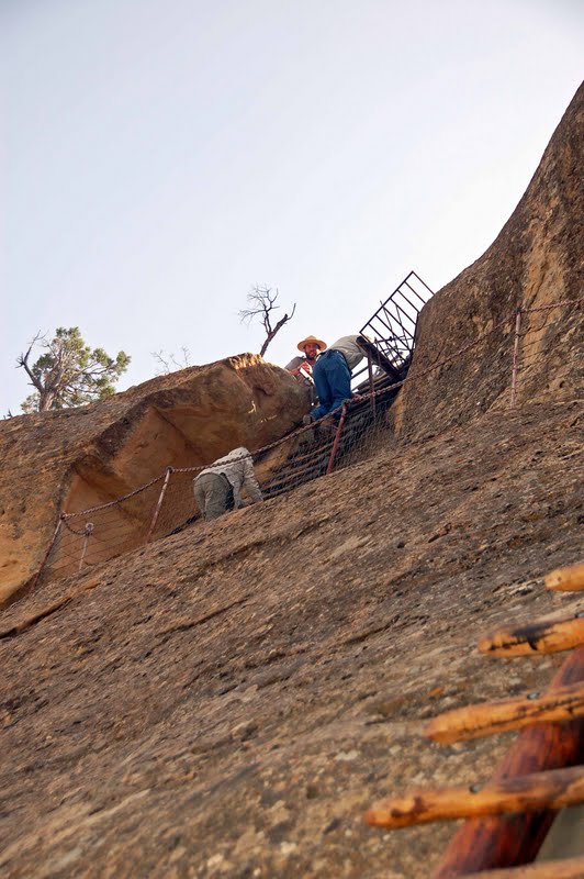
Ah yes, the exit...of course, what went down must go up! But first was an exciting crawl on hands and knees through a very small narrow tunnel to reach the outside of the cliff alcove...I still don't know how these people did this! Ok, so we have this ladder first.....
Then this really interesting walk up the rock face, I think the park service was pretty smart putting in the chains to help the walk up :-)!...
Then this last ladder to the top...see the ranger at the top, waiting to help? :-).
Yes, it was scary, but I did it! I'm very glad I did, as it was so interesting to visit these sites. Unfortunately, it was now already after 4PM. We had an hour ride out of the park, and then another half hour back to Durango to pick up the dogs at daycare by 6PM. So, sadly, we had to make haste away without visiting the wonderful Chapin Mesa museum, a self-guided tour of Spruce Tree House, which is the park's best preserved site, or doing the 3 mile round-trip hike to Petroglyph Point, where the park's largest petroglyph panel (12 feet across) is located. Bear in mind that a whole other section of the park, Wetherill Mesa, wasn't even opened! So, I think you could easily spend two, if not three days, visiting this park, and we will return again someday. I have to laugh at the guide put out by the National Park Service that says, "Plan to spend at least half a day exploring the unique opportunities in the park". !!I guess they don't know those of us that take HOURS longer every place than the average tourist :-).
Well, I apologize for the length of this post, but I really wanted to express how enjoyable I found the experience. My entire roster of photos can be seen
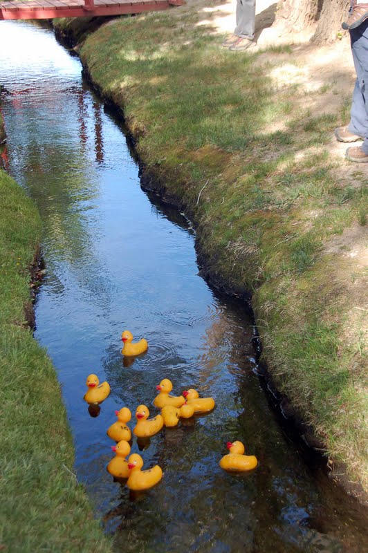
here at Flickr if you wish to see them. I will let you all go now, with the promise of pictures from our drive back to Chalk Creek along the Silverthread Scenic Byway, and also pictures of our big (Sherry this is for you) rubber duckie races over Memorial Day here at the campground. Thanks for hanging in there until the end!