June 19 - June 27
Leaving Tok behind for now - we will be back through there on our way south - we headed for our first stop at Klutina Salmon Charters and Fish Camp in Copper Center. The objective here was fishing the Copper River for "reds," otherwise known as sockeye salmon. We stayed for 3 nights in one of the most rustic campgrounds we've ever stayed in. Only 30 amp electric hookup here, with a freshwater fill station and a dump station up the road for our waste tanks. But we are right along the river, a few steps away from fishing, and that's what it's mostly about!

Office to check in and gather information on fishing. The run was just barely getting started.

One of the access points to the river past the raft. It was flowing very fast.

Al and Dan out there giving it their all.
.JPG)
Jonell trying her luck. It takes getting used to the casting motion...so I'm told!
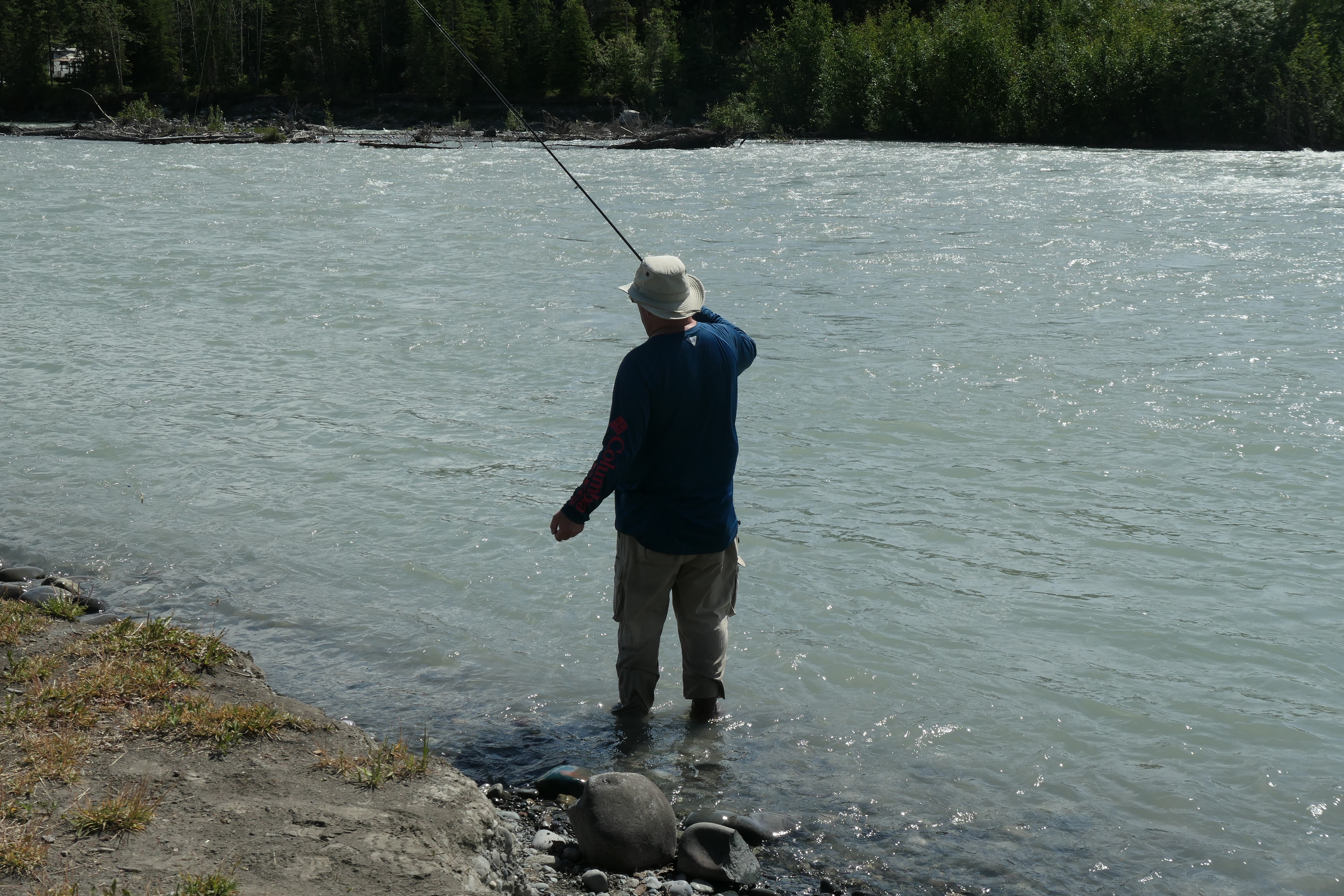
More casting.

Dan caught one pretty quickly!

Al got in on the action as well.
They only caught one apiece, but it was a start to what we hope will be many fish caught and packed up for the summer.
.JPG)
While in Copper Center, we spent one morning visiting the Wrangell-St. Elias National Park Visitor Center. It is America's largest national park at 13.2 million acres, an area that would encompass Yellowstone National Park, Yosemite National Park, and the country of Switzerland combined! The Wrangells are volcanic in origin, but only Mount Wrangell remains active, last erupting in 1900.
From the national park website:
Park Superlatives:

The Visitor Center was very interesting, with an informative movie and two exhibit buildings.
.JPG)
A view of the mountain range featuring Mount Drum and Mount Wrangell
.JPG)
We took a short hike along a trail through the boreal forest area, and I will say I have never seen such a multitude of mosquitoes before. It was a short walk and I can say I was quite happy it was!
From Klutina Salmon Charters and Fish Camp, we moved after three days 48 miles down the road to Wrangell View RV Park. The sole mission for going here was to visit another area of the
Wrangell-St. Elias National Park, the McCarthy-Kennicott Mine area. The interesting thing about this is that first there is a 33-mile drive down the Edgarton Highway, which was a pretty rustic road in itself towards the end, with many twisty, up-and-down spots landing us in another small, very rustic campground which surprisingly had full hook-ups - living the life with 50-amp electric!
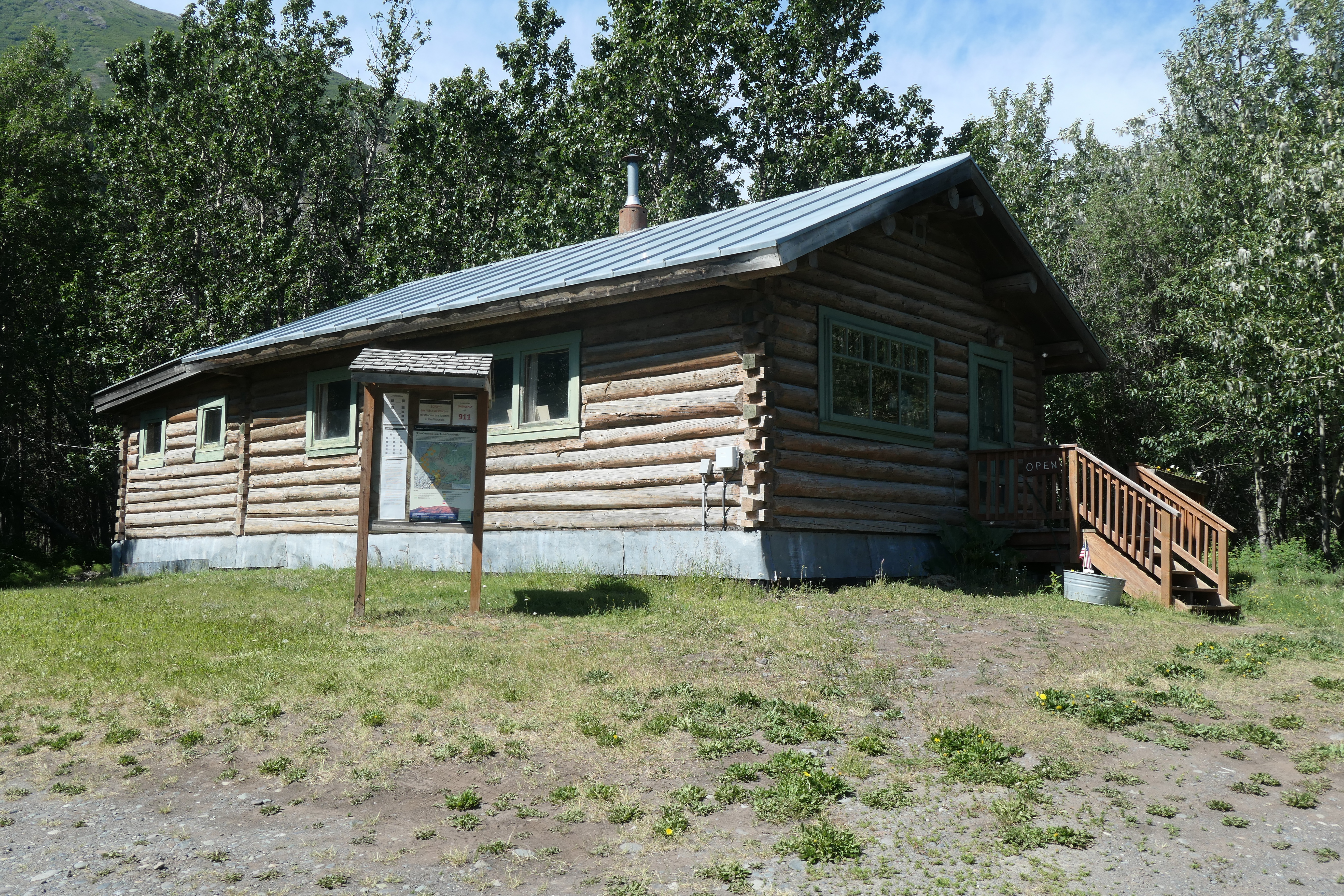
After arriving at the campground, we took a drive to the Wrangell-St. Elias National Park ranger station for visitor information. It's an old log cabin, originally the Ed S. Orr Stage Company, where passengers, freight, and mail were transported to and from Fairbanks 2 to 3 times a week. The journey took 4 days and advertised "an abundance of fur robes and carbon-heated foot warmers."
.JPG)
We drove a little further down to the bridge over the Copper River. Fish wheels, https://en.wikipedia.org/wiki/Fish_wheel, were seen to the north, but we were unable to drive down to them for a close inspection. And then we also saw a big moose along the roadside on the way back to the campground.
.JPG)
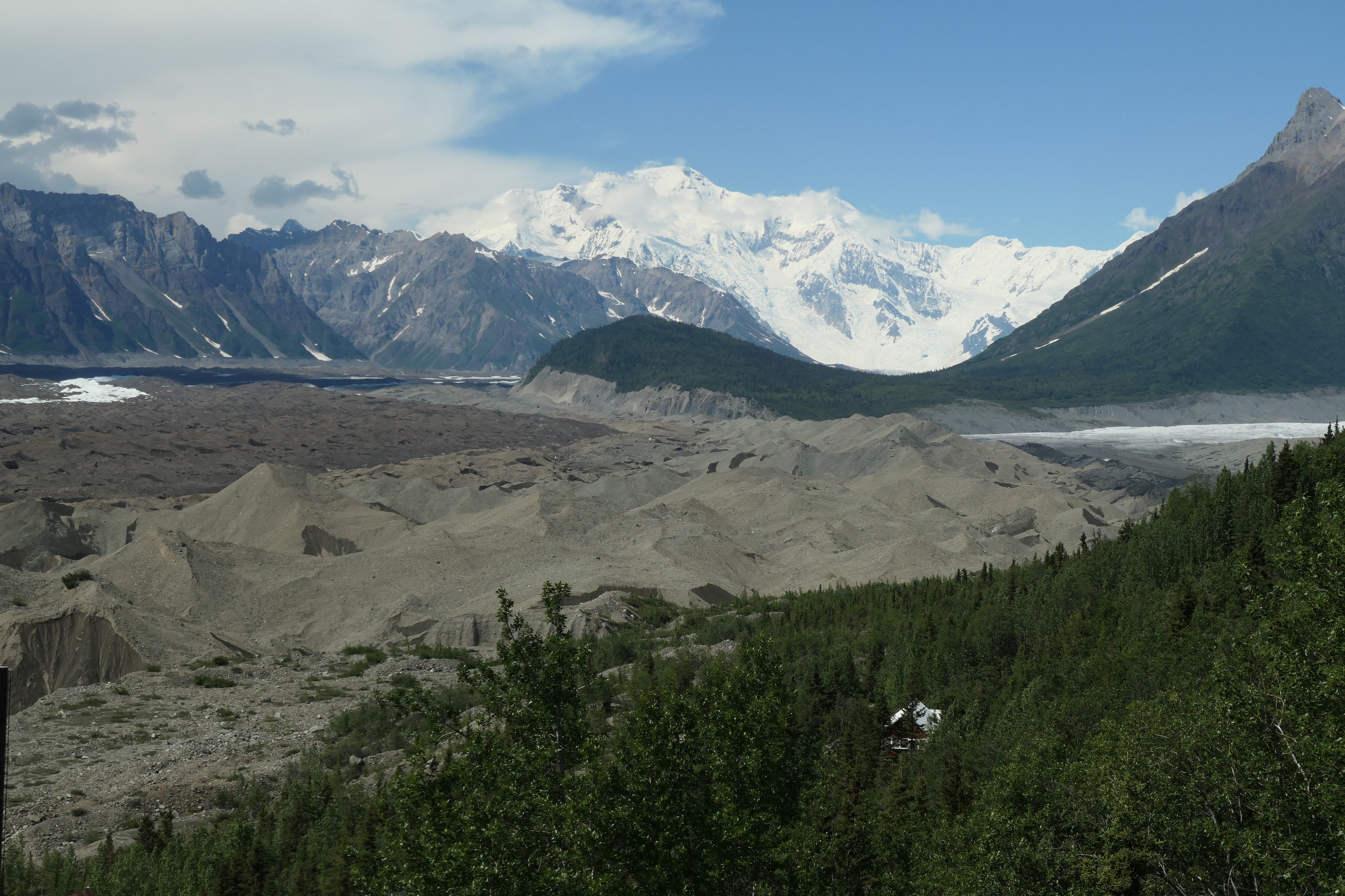
From Chitina, it's a 60-mile trip down a road that roughly follows the historic 196-mile long Copper River and Northwestern Railway railroad grade leading to the town of McCarthy. It takes a little over two hours to drive the 60 miles. After the railway was abandoned in 1938, most of the rails and ties were eventually removed. The corridor was turned over to the State of Alaska which placed culverts and created a road in the 1960s. In 1971, a new bridge was constructed over the Copper River and the railbed was covered with gravel, creating the McCarthy Road.

Some of the views along the drive.

The Kuskulana Bridge spans a 238-foot gorge and is a one-lane bridge. The 600-foot steel bridge was redecked in 1988 and guard rails installed.

At the end of the road, you have to park your vehicle and then walk across the river on a footbridge. Once across, there are shuttle vans to take you into McCarthy, and then another 4 miles to the Kennecott Mine area, part of the national park system.

Two prospectors, Clarence Warner and Jack Smith, returned from the Wrangell Mountains in the summer of 1900 with samples of what turned out to be 70 percent chalcocite they found above the east edge of Kennicott Glacier. The find would prove to be one of the richest copper deposits ever found anywhere.

It was a herculean effort to get the mine camp and buildings going, from amassing the necessary funds to figuring out what was needed and actually getting the materials to this remote location. By the end of the mine's run, they were operating a total of 5 mines with approximately 600 workers, and at least $200 million worth of ore was mined and shipped out.

The Kennecott Copper Corporation grew into one of the largest minerals companies in the world, reaping huge profits spurred by the country's high demand for copper. Late in 1938, the mines closed and the train left, never to return.

The Wrangell-St. Elias National Park was established in 1980, but the park service did not acquire the buildings and lands of the Kennecott Mines National Historic Landmark until June of 1998.
You may notice I have used two different spellings, "Kennecott" and "Kennicott." No one really knows why the Kennecott Copper Corporation ended up with a different spelling than its namesake, the Kennicott Glacier. Most say it was a clerical error! After the mines closed in 1938, many references to the area included the "i" spelling of Kennicott to distinguish what remained from the departed Kennecott Copper Corporation. In general today, Kennecott tends to indicate historic features and the settlement, while Kennecott indicates natural features, such as the glacier, river, and valley.
This is the moraine of the Kennicott Glacier. It looks like dirt but it is dirt on top of ice that's 500 feet thick.

Inside the mill building of the copper mine.

Jonell descending a ladder - one of many- in the mill building. Hardhats were necessary attire due to the low overhangs in many areas. Al did get to test the hardhat out!

Vats that stored ammonia in a separate processing building. The ammonia helped separate the copper from the worthless rock. That process helped them achieve an 85 percent recovery rate of the copper.

Another view of the mill buildings from the bottom. An interesting fact about the tour is that in case of fire in the building during the tour, they were instructed to exit the building to the left in this picture and scramble down the rubble slope alongside the building. However, at the bottom of this rubble slope is this sign:

Once the tour was over, then they were told about the sign!
Once the tour was completed, it was time to backtrack: shuttle from Kennicott to McCarthy, walk about a mile back to the footbridge, cross the footbridge to retrieve the car, then 2 hours back down McCarthy Road. All told, it was about a 12-hour excursion. But all participants enjoyed it very much and said it was well worth the time invested. It's definitely one of the more remote national park service sites ever visited.
After our two nights in Chitina, we headed another 115 miles down the road to the port town of Valdez. We had a wonderful spot right along the waterfront in the Bear Paw II Adult Campground. The marina is to the left, some commercial docks along the right, and those beautiful mountains are straight ahead. Although, in reality, the mountains completely surround you. It seems as if, since we started along the Alaskan Highway in British Columbia, we have been surrounded by mountains for literally over a thousand miles.

The first thing we did upon arrival in Valdez was head down to the boat docks. Al and Dan have a fishing charter on Sunday to check in for, and the four of us have a wildlife/glacier cruise Monday to check in for. It was overcast from the clouds that were settled in around the mountains, but it is beautiful. The town and harbor remind me of what Montauk was like 50-60 years ago when it was just a "quaint little drinking village with a fishing problem." Except for the towering mountains surrounding it, of course!
.JPG)
.JPG)
.JPG)
.JPG)
I've never seen this before, but they have fish cleaning stations all along the docks. As the charters come in, the catches are given to fish cleaners who filet the catch in an astoundingly quick fashion. This chute is where all the waste is discarded and washed down to a catch basin. It is all then discharged into the water for nature to take its course.
.JPG)
This eagle is sitting on the catch basin, being part of "nature taking its course"!
.JPG)
The office of the Lu-Lu Belle, a glacier/wildlife cruise that we are going on Monday. This will be in the next blog, along with the fishing trip Dan and Al went on.

Worthington Glacier, along the Richardson Highway going into Valdez, is a good example of a small valley glacier. It is one of the most road accessible, being seen from the highway and just a short walk down a trail for a prime viewing spot.

The pond created by the terminal moraine of the melting glacier.


Two of the beautiful views through Keystone Canyon along the Richardson Highway.

So this is interesting. This is a tunnel that was hand-cut into the solid rock of Keystone Canyon in anticipation of the railroad coming through. Nine companies were arguing over the rights to the shortest route from the coast to the copper mines at Kennicott. A feud erupted and a gunfight ensued among the workers, interrupting the project. It was ultimately never completed.

Bridal Veil Falls

Horsetail Falls
The next blog will continue with the last two days in Valdez and the trip continuing on to Palmer, Alaska.
An adult RV park? -wink wink- :-)
ReplyDeleteSome beautiful country!