Welcome to our Adventure!

Al and I are thrilled that you have found your way to our blog. We hope you enjoy reading our journal and viewing our photographs of the natural wonder of our United States of America. Let's hit the road together!
Homer, Alaska

Thursday, August 16, 2012

Geocaching Fun, and a Face Plant

The past couple of weeks we've been staying close to camp, since our journey over to the Black Canyon and Ouray. We've recenently started geocaching, mainly due to the enthusiastic discussions with our fellow workamper Sandi. Most of you who RV know about geocaching already, but for those who don't, you can learn all about it here. As Sandi's husband Joe explains it, you use a handheld GPS worth a few hundred dollars, using technology worth billions of dollars (satellites) to "find stuff" :-). It's a modern day treasure hunt. The neat thing about it is that you go places looking for these caches that you may never have discovered otherwise.

So on one of our days off the past week, we picked one that was close by, and decided to go find it. It sounded nice, at the top of a waterfall, and would be a nice walk to take the pups on as well. We had planned on leaving early, but were also making breakfast that morning for the other workampers...omelets in a bag. We were going to make them for our "breakfast for dinner" potluck, but had some technical issues at the time. Being that we had three dozen eggs, we offered to make breakfast Sunday morning instead :-). So we got off to a little later start than we had hoped...after all, it is August in the mountains, and the afternoon rains almost always come through on the mountain. Anyway, we loaded up the water bottles, got our co-ordinates for the cache, and set off on Brown's Creek Trail to the waterfall.


The first mile was ALL uphill...lots of huffing and puffing, but great views of the valley behind us

We walked through trees...

and meadows....

and over logs crossing streams...the dogs had a definite advantage here!

and finally made it to Brown's Creek Waterfalls. It was really pretty, but I had read our directions wrong, and instead of being a 3 mile round trip hike, it was 3 miles one way. 

The cache co-ordinates were indicating that the cache was to our right, up the huge pile of boulders....I was not confident enough to climb up the pile, and with a 3 mile hike facing me for the return trip, did not want to walk further to find a route around. But we did see some nice waterfalls!

It was a very rocky hike back down the mountain, and we needed to go slow and careful to not twist an ankle!

A dip in Brown's Creeks at the end was refreshing for the pups!

The next day we wanted to go out again, but after six miles my body rebelled about doing another hike! So we picked a scenic drive, from the town of Como over the Boreas Pass to Breckenridge. It was a beautiful day, one of the monthly residents, Mike and Gigi, had recommended it, so we packed up the pups, maps, some geocache co-ordinates, and off we went again.
My research had told me to stop at Mountain Man Gallery for a roadmap guide to the pass, with numbered markers to guide us through the history of the pass. Unfortunately, the owner, also the postmaster, after she finished loading mail into the old-fashioned metal boxes in the back of the gallery, told me the markers were all taken down, so the guide was useless and she didn't print it anymore. Well, alrighty then!

Como has several interesting buildings, this train roundhouse is one. The historical societies raise money to slowly restore these buildings.

Up the road we went, looking for our first geocache...Roberts Cabin


Found it!

On the road again for the next one...

Al spotted this one!

Our last cache required more searching...

Beautiful view!

Even Chelsea joined in the climb

and another find :-).

That was our last cache for the day. We headed onward up to the summit....
Another Continental Divide Pass sign for my collection :-).


Several buildings were restored by historical societies, and I couldn't resist taking a picture of this sign :-).


We continued down the pass and into the ski town Breckenridge..looking for some lunch before heading back to Chalk Creek. We found a puppy-friendly spot at The Whale's Tale, also known as the gathering spot for the "After the Catch: season six" episode of "Deadliest Catch" series. Lunch was tasty, and we strolled around town for awhile...

A cute store with beautiful gardens

Casey was quite concerned about this!

Cupcakes, anyone??

So, we had a very nice couple of days off, and got started on a new hobby, geocaching. But lest anyone thinks that only good things happen around here, :-), I do have to admit that I had a bit of a fall yesterday :-(. It was totally my fault, and was on the flattest, easiest trail around that we walk on. We had gone out after working the morning shift, and took the dogs with us. After finding a few caches, we decided to take them for a quick walk on River Walk, in town, before going to dinner. I saw some cool ducks on the river, and I was paying attention to my phone, trying to ID the ducks, rather than what was going on around me. Well, Chelsea, whose leash I was holding, decided she had to go see another dog coming our way, and took off. I was completely caught off guard, and ended up getting dragged down, doing a face plant into the gravel path. Long story short, I am now sporting a very fashionable 10 stitches on my chin. And no, there are no pictures :-). Just goes to show you, it only takes seconds of inattention to lead to an accident. Otherwise, we're all fine, and its a minor bump in the road. Onto the next adventure!


Thursday, August 9, 2012

Fun in Ouray

Time really flies when you're having fun! It's been two weeks since our day in beautiful Ouray, and I am so sorry for not getting our pictures and experiences posted until now. Its not as easy as I had thought to keep a blog current, between working and playing to experience the adventures I would like to write about :-)! Well, I've got my pictures ready from our jeeping experience in Ouray, so sit back and enjoy! I have the full set loaded up here at Flickr for those who would like to see it all!

Our first adventure started with our arrival in Ouray. We had spent the day exploring the north rim of the Black Canyon of the Gunnison, and as we drove to Ouray, it started to rain and a fierce thunderstorm rolled over us. We had rented a jeep from Farabee's Jeeps at the Riverside Inn, and they allow you to pick it up the night before so you can get an early start to your day the next morning. This seemed like a good idea to me, as rains usually arrive mid-afternoon, and they also have a firm "return by 5:00 PM policy" that you don't want to miss! So we picked up the jeep and had our lesson on driving it, and off we went to find our cabin we had reserved. It looked really nice online, and we were looking forward to getting settled in for the night.

Our glitch occurred upon finding our cabin. First I had a difficult time finding a place to park the truck, and upon finding that, I went to check in. The office was closed for the moment, but she had told me the cabin would be unlocked and to just go inside. That would be fine, except when I went around to the cabin, I saw through the window that there was already somebody inside, relaxing on the bed. Hmmm...ok, now what? I headed back for the office, and to make a long story short, they had written down my date of arrival incorrectly, and thought I was coming in the next day. She was extremely apologetic, and did make a few calls and found us another pet-friendly room nearby...whew, at least I had a place to lay my head :-)! The Ouray Victorian Inn was very nice, and I have to say the bathroom was awesome! I will say, having unlimited hot water in a shower that you can turn around in without hitting your elbows is a thing to be treasured :-). We had dinner at the historic Western Hotel that was very good, although the background music playing (80's disco) was a little odd ;-). Then it was into bed as we planned on heading out early for our adventure...we had a route suggested to us by the jeep company of driving down a portion of the "Million Dollar Highway" to a turn-off for Ophir Pass, go into Telluride, and then off-road again over Imogene Pass back to Ouray. The route should take us most of the day, taking into account time for lunch and pictures. And I have to say she was spot-on with the time guide! Onto the pictures....

The beautiful red-tinged mountains

The start of our off-road ride over Ophir Pass. The Ophir Pass has the reputation of being one of the easiest high mountain passes in the San Juan Mountains...a good way to start for us jeeping novices!!

The beautiful forested Middle Mineral Creek area

At the summit...11,789 feet. Great view to the west!

The kids ready to move on!

The trail...getting a little more intense! hang on and don't look down!

Driving through an awesome aspen forest as we approach the town of Ophir

I love this sign!

On to Telluride...a nice looking town that seemed very oriented towards the outdoorsy type of folks. We stopped here for a restroom break, and to pick up a sandwich to take on the next trail with us. We were SO happy when we checked out Clark's Market  and saw that their deli department made sandwiches and had Boarshead cold cuts! SCORE!! There's nothing better than thin sliced Boarshead boiled ham, and believe me, we both enjoyed our sandwiches very much :-).

Sandwiches in hand, we headed out of town towards Imogene Pass. Buzzed right past the turnoff, and ended up at the entrance to Black Bear Pass, which is NOT a drive we were looking for...that one is one of the most difficult jeeping roads there are, and the rental company actually had us sign a form that we WOULD NOT take their jeep on...no worries there! Turned around, re-oriented ourselves, and found the turn-off.

Far off view of Bridal Veil Falls. I love the house at the top, it reminds me of Carl's house in the Disney movie "Up" :-).

Imogene Pass is the second highest driveable pass in Colorado. It was also very scenic, although a careful eye was kept on the road, which, as you see, is very rocky, narrow, and a long drop off the side :-).

Social Tunnel

Ruins at the Tomboy Mining Ghost Town. The town closed in 1927 when the mine ran out. 900 folks lived here at one time!

Leaving Tomboy behind and headed to the summit....

How would you like to deliver mail to this spot??

At the top of the world...13,180 feet...awesome!

Wildflowers everywhere

Going down was just as exciting as going up :-). What made the trip down even more interesting was a jeep that had broken down on the way up, and no-one was able to pass at the spot he was in. Eventually, with some pushing help from Al, they got it rolling backwards down the road to a spot wide enough to allow others to pass. I wouldn't want that tow truck bill!

Found a waterfall when we stopped to walk around at one point

Finally, back to Ouray. We had some time before the jeep needed to be returned, so it seemed like a good time to stop for some ice cream :-).

Dinner was at the True Grit Cafe, devoted to that American legend, John Wayne. It was very good, but way more food on the plate than we could eat! We both had chicken fried steak with country gravy and mashed potatoes, I think we could have shared a plate :-).

I was told by several people that no trip to Ouray was complete without a stop at Mouse's Chocolates, so who was I to say different. Some chocolate truffles and scrap cookies seemed just the way to wind up our day, wouldn't you say? Scrap cookies are their own creation...it's a sugar cookie dough, and then they throw in any scraps of chocolate and candies they have leftover from the day's baking...so the cookie is always different...but always good :-). Good thing Ouray isn't close to Chalk Creek!

So, that was our adventure in Ouray, our first time jeeping in the back country, and we had a great time. We will most definitely be returning to that area in the future. But stay tuned, we have more fun to show you as soon as I get pictures ready, and we've begun a foray into a new type of adventure...we've started geocaching...all kinds of new fun to be had... :-).


Thursday, August 2, 2012

Rim to Rim Expedition

Before I start today's adventure, I have a small blurb that I would like folks to hear: we have been working here at Chalk Creek Campground all summer, and I think we've managed to convey how great a time we have had here. We will be moving on to a different area of the country next year, which leaves a vacant workamper couple spot for next year. If any of my readers might be interested in information about working here, please drop me an email and I'll fill you in and put you in touch with the Karlsson's.

On our way to our adventure in Ouray last week, we stopped at the Black Canyon of the Gunnison National Park both going to Ouray and coming back from Ouray. To do both rims of the Black Canyon is too much for one day, so wanting to experience both the North Rim and the South Rim, we split it up into the two days, incorporating the experience into our driving days. No sense wasting time, now, is there?

The Black Canyon is a deep, precipitous gorge hacked out of the ancient bedrock by the Gunnison River. The National Park protects 12 miles of the 50-mile-long canyon. The Black Canyon slices through an upift that reaches elevations above 8,000 feet. Time and the flowing river created the Canyon, which is between two and three million years old. The Gunnison River has one of the nation's steepest river gradients, dropping 2,150 feet from the canyon head at Sapinero (now under the Blue Mesa reservoir) to its North Fork junction, an average fall of 43 feet per mile. In the two miles from Pulpit Rock overview to Chasm View overlook, it descends and astounding 480 feet. That steep gradient, combined with the abrasion of tumbling boulders on the riverbed, gives the Gunnison a sharp cutting edge. Geologists estimate the river deepens the canyon by about one inch every century. But enough words, let's get onto some pictures!

We drove the North Rim on our first day...this is a picture of the pontoon boat at the dock from the Morrow Point Reservoir tour. 

View of the South Rim and the San Juan Mountain range in the distance

We drove to the ranger station to check in and get my National Park stamp :-), with the intention of hiking to Exclamation Point, described in my photography guide as the best view of the canyon in the park. However, there was a very bad sign at the trailhead, at least for us..."no dogs". Ugh! I was discussing this with the ranger, who agreed with me that we are the only user group discriminated against in the National Park system. We were allowed to walk them on the shorter overlook trails along the rim, so that's what we did. We had a picnic lunch in the campground, and then walked down the Chasm View Trail to see this view of the Painted Wall and the streaked walls.

There was no parking directly at any overlook, there was always a short trail to walk to the overlook. The trails are very well-maintained and easy to follow.

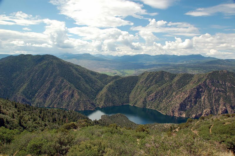
The river cutting its path through the canyon

Looking down at rock formations

This photo was taken at Kneeling Camel Overlook....can you see the camel??

Onto the South Rim. This is taken at Gunnison Point. We had elected to drive the South Rim on our return trip from Ouray to the campground. Even though the rims are only about 1100 feet apart at points, it is a long drive, 2 1/2 to 3 hour drive each way. And no, there is no bridge from rim to rim...apparently people do ask :-).

Al and the kids at Pulpit  Rock Overlook

View of the West Elk Mountains

A great view of the Painted Wall at Cedar Point overlook. Painted Wall is Colorado's highest cliff, with a 2,240-foot vertical rise from base to rim. The "painted" strips are pink pegmatite bands slashing across the cliff. (pegmatite is a coarse-grained igneous rock for the geologists in the crowd).

A final view of the canyon, and river. 

We really enjoyed our days exploring the Black Canyon of the Gunnison. For more adventurous, and hardy, souls there's hiking down into the canyon, fishing, even rock climbing. We did have an enjoyable day just driving the rims, and walking each of the overlook trails. 

Next up on the adventure trail: our first experience with off-road jeeping in lovely Ouray, otherwise known as the Switzerland of America!