We saw bears! I'm doing the happy bear dance :-). I'm so thrilled. less than three weeks on the road, and I saw bears!
First things first though. Wednesday was the formal start of our classes. Between the two of us we attended each one Wednesday: 1. No Right Way to Full-Time: Evaluating the Options 2. Emotional Aspects of the Full-timing Decision 3. What Does It Cost to Full-time? 4. Internet on the Road. Each was was very informative, and whereas most of the information can be found by digging through the RV-Dreams website, I found the question and answer session after each lecture to be very interesting, often bringing up different topics and ways of looking at things. There's an afternoon break between 3pm and 6pm, and then the chili cook-off/dinner started. I believe there were about 40 different pots of chili brought in, along with all the fixin's and desserts (my favorite part of the meal!). After dinner, everyone was invited to bring their favorite useful and/or amusing rv gadget for show and tell. That was very interesting and informative as well as being quite funny at times.
Today we continued getting the pups used to being in the trailer on their own, and it seems to be working out quite well, better than I expected, actually. We pull the shades, leave the fan on, the tv on, give them their cookies, and tell them to stay, we'll be back soon. So far, so good. Casey seems to like staying on the bed while we're gone, and Chelsea just sleeps on the couch! No barking at all that we've been able to tell, and our neighbors tell us they haven't heard anything, so GOOD DOGS!!
On an amusing side, Nancy next door told us to check our pin box, she's seen a bird flying in and out of it. Sure enough, as I was sitting at the picnic table, I saw a little house finch fly over with a twig and duck into the pin box. The little guys are building a nest in there! I shooed him away, and after making sure it wasn't occupied, we put a plastic garbage bag around it to keep them from going in anymore. We sure don't want to get stuck here because we're waiting for a family of finches to be born! Shortly afterwards I saw both of them come flying in, and boy, were they not happy campers when they couldn't get in. Poor things, they were flapping their little wings hovering in front of it, trying to figure out what happened. Oh well, there's plenty of spots better for them to raise their family!
Thursday morning we attended more classes: 1.Buying an RV-pros Cons and Must-Haves 2. Selecting a "Home Base" and Insurance Considerations 3. Working on the Road. The last class for the day was TV Options for RVers, but being that we are set with our satellite and DirectTV, we decided to skip that one and head out to Cades Cove. We were going to do that on Friday, but it's not supposed to be a nice day on Friday, and Thursday afternoon was beautiful! So we got some lunch, and headed off to the Smoky Mountains and the driving tour at Cades Cove.
This is a very popular trip within the National Park, and is a showcase for some of the most inspiring and cultural treasures that the Southern Appalachian Mountains have to offer. Now, for those of you at home, a "cove" in Smoky Mountain vernacular is not the same thing that we consider a cove, which of course is a body of water. Here, a cove is a relatively flat valley between mountains or ridges. The primary access to Cades Cove is an 11-mile, one-way road Cades Cove Loop Road, shared equally between motorists, bicyclists and pedestrians.
Cades Cove was primarily a farming community, and in 1900 about 125 families lived through the area. The main road was generally the route followed today, with about five other narrow unpaved roads running throughout. These are now some of the 7 hiking trails easily reached from the loop road. We had not gotten too far along the route when we saw cars piling up alongside the road. It was quite reminiscent of our time in Africa, when you knew if you saw a gang of vehicles pulled over to the side, there was some sort of wildlife to see :-). Pulling off, we saw in the distance three black bears. It was so exciting, and they were heading down the ridge towards us! I jumped out of the truck to take pictures (no, I did not get too close, and happily, no-one else was trying to either!).
They stopped in a clearing where there were several fallen trees and a lot of grassy area. There must have been something tasty there for them to eat. Two of them were at this log for quite awhile, grubbing up something.
This one headed straight for me for a short while, but it is further away than it looks. Thank goodness for telephoto lenses!
This shows the grassy glen they were picking through. Shortly after this, someone at the other end of the parking area did something to spook them, and they took off back up the ridge. It was so interesting to watch them for a little while though, and really, they didn't seem to concerned about people observing them. And the pups were great; we had the windows up, but they didn't carry on at all. Good dogs!
We continued on with our drive, and took some more pictures of the preserved buildings along the way.
This is the Primitive Baptist Church, originally built in 1827, and replaced in 1887. I found it interesting that during the Civil War, they ceased having services, and official church correspondence explained: "We the Primitive Baptist Church in Blount County in Cades Cove, do show the public why we have not kept up our church meeting. It was on account of the Rebellion and we was Union people and the Rebels was too strong here in Cades Cove. Our preacher was obliged to leave sometimes, and thank God we once more can meet." I thought that was interesting!
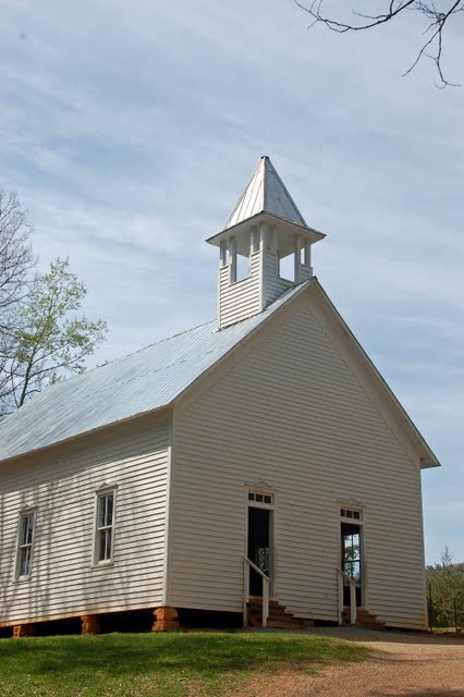
This is the Methodist Church, built in 1902, in 115 days for $115.00!
View from the west side of the cove looking across to the east. Casey was really eyeing up the fields! Wouldn't it have been great for a run!
Some more of the fencing that I really like. This is the entrance to the Cable Mill area, where there's a walking tour of the historic buildings on the site.
View of the Gregg-Cable house, with the barn in the background.
The drive-through barn behind the house. Two men with pitchforks could easily unload a wagon load of hay that had been pulled though the middle.
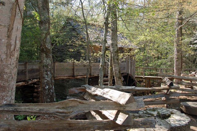
This is a water=powered grist mill and sawmill built in 1870. It was operated well into the twentieth century, but ceased operating when it couldn't compete with the new more modern steam powered mills.
Some old farm equipment stored at the Cantilever barn near the mill creek.
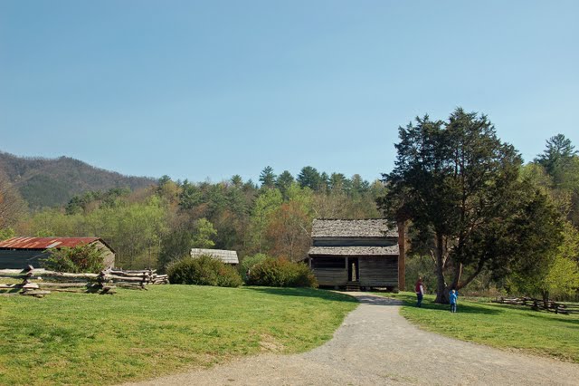
The Dan Lawson Place. This house has a brick chimney, very unusual in 1856 for this area.
The view across the cove from the eastern side of the loop road, looking west.
So that was our quick tour of Cades Cove, and I hope you found it interesting :-). We had to quickly make our way back to River Plantation, as we had our pot-luck dinner at 6PM, and afterwards a "friendly" game of RV Family Feud. Now, that was different. My team was eliminated in the second round, but Al, as team captain, (guess you just can't take the leader out of him lol) took his team down to the final round, and lost on the final question.oh well! :-).
Today, Friday, is a "free day"...no classes or official events scheduled. Al went for more fly-fishing instruction, and I'm doing laundry, as its piling up and I don't think we have laundry facilities at our next stop in Kentucky. We are waiting for some bad weather, and high winds to move through tonight, so the awning is rolled up and the chairs will be stowed. So, until the next post, enjoy your day, wherever you are!
Welcome to our Adventure!
Al and I are thrilled that you have found your way to our blog. We hope you enjoy reading our journal and viewing our photographs of the natural wonder of our United States of America. Let's hit the road together!
Homer, Alaska
Friday, April 15, 2011
Tuesday, April 12, 2011
Travel to Sevierville TN and the Smoky Mountains N.P.
Sunday we left High Falls S.P. and headed towards River Plantation RV Park in Sevierville, TN. This will be our stopping point for the next week, where we are attending the RV-Dreams Spring Rally. It was about a 4 1/2 hour drive, and we did it in 6 hours :-). We had a slight detour as we stopped for fuel at a rather big rig un-friendly exit, and ended up navigating through a small town to get back onto the highway. Guess I had better carry "The Next Exit" book in the truck with me :-).
River Plantation is a nice campground, right off Parkway in Sevierville. Parkway runs from I40 through Sevierville and Pigeon Forge to the north entrance of the Smoky Mountain National Park. As one of the rally attendees stated, Pigeon Forge is "like Myrtle Beach on steroids"! I was dumb-founded as we drove through Pigeon Forge, and will take some video next time and try to post it here on the blog....and the folks back home think 7-11 moving into town will ruin everything! :-).
We arrived around 4PM, and quickly set up. The sites are wide, paved, mostly level, and there's a little shade tree! Our hosts, Linda and Howard Payne of RV-Dreams, were on hand to welcome us, and invite us down to their site after 5Pm for "the circle". This is a tradition that has started at rallies, "happy hour" at Linda and Howard's site, everyone brings their chairs down, sets up a circle, and conversation abounds. It's really neat, and even as strangers, we were welcomed by everyone.
The rally does not officially begin until Tuesday, when registration takes place, and there's a welcome dinner and ice-breaker gathering. Classes start Wednesday. So Monday was a free day, we we took advantage of the weather being sunny to engage in some outdoor activity.
Before we had left Sag Harbor, a friend of Al's had given him fly-fishing equipment to take with him, as this will be the predominantly form of fishing he'll be engaged in from now on (except of course on visits back to Long Island where I'm sure there will plenty of salt water fishing on the agenda :-)). We discovered one of the rally attendees, Mike, is a guide from Maine, and was offering fly-fishing instruction for anyone who would like to join in. So that is what Al was doing Monday morning...learning about casting! It was such a nice thing to do, as I know it is quite expensive to take fly-fishing lessons. In the meantime, I spent the morning working on finances, getting the checkbook updated, paying bills, and updating the budget spreadsheets. I also got a dinner list for the next week set, and a grocery list set for Tuesday shopping...hey! what's wrong with this picture? :-).
After he returned, we decided to head out and try to do a driving tour before bad weather set in...there were thunderstorms forecast for late afternoon and all night. After going to the post office to mail out a couple of packages, and CVS to renew some prescriptions, we headed to the Smoky Mountains. Our destination was the Cherokee Orchard Road and Roaring Fork Motor Nature Trail. This driving tour was the closest one, and being that we weren't sure how long the weather would hold, it seemed the smartest choice. We would also like to do Cades Cove, but it's much longer and says to plan about 4 hours total to do the trip. We're planning on doing that on Friday, our next free day.
We stopped at the Gatlinburg Welcome Center, and picked up Smoky Starter Kit for maps and general guides, and also Smokies Road Guide; I think we're set! We then drove to the Motor nature trail, and started heading up, Initially, it's a two way road, but once you start the motor trail, it's a 6 mile, one way, windy twisty loop road. No buses, motorhomes or trailers allowed, and I can see why! At times, I wasn't sure our big old pick-up was going to twist around without hitting something!
This was one of the wider sections of roadway :-).
Roaring Fork is the mountain stream that courses down Mt. Le Conte, and was also the name of a farming community up here that was settled in the 1830's to 1840's. About 2 dozen families eked out a living up here, but it was very harsh, and the land not real hospitable to farming. This is a view from the highest point of the motor trail. You can see the mountain peaks and ridges rolling across the distance, but over the last 50 year, air pollution has created a haze that makes seeing long distances impossible any more.
This is the "upscale" section of Roaring Fork, the Alfred Reagan place. He was not only a farmer, but a carpenter, and an astute businessman at the time. This was his final, expanded home for his family, having sawed board paneling and ceilings (all hand-planed) and painted with "all three colors that Sears Roebuck had"! He had also built this mill across the street, and milled the wheat for other farmers.
We stopped at another pull-off, and as we got out to walk down to the side of the stream, as Casey bounded down the path, all of a sudden this huge flock of yellow and black butterflies came crashing upwards! They must have been resting on the rocks below the overhang, and our coming down disturbed them. The were flying all over the place, but I had a very difficult time getting a good photo...this is the best I could do:
At the very end of the motor nature road, there's a waterfall called "Place of a Thousand Drips". It's not a roaring impressive, waterfall, but a series of small streams running over in many different areas, slowly cutting away at the bedrock, forming a new side canyon.
River Plantation is a nice campground, right off Parkway in Sevierville. Parkway runs from I40 through Sevierville and Pigeon Forge to the north entrance of the Smoky Mountain National Park. As one of the rally attendees stated, Pigeon Forge is "like Myrtle Beach on steroids"! I was dumb-founded as we drove through Pigeon Forge, and will take some video next time and try to post it here on the blog....and the folks back home think 7-11 moving into town will ruin everything! :-).
We arrived around 4PM, and quickly set up. The sites are wide, paved, mostly level, and there's a little shade tree! Our hosts, Linda and Howard Payne of RV-Dreams, were on hand to welcome us, and invite us down to their site after 5Pm for "the circle". This is a tradition that has started at rallies, "happy hour" at Linda and Howard's site, everyone brings their chairs down, sets up a circle, and conversation abounds. It's really neat, and even as strangers, we were welcomed by everyone.
The rally does not officially begin until Tuesday, when registration takes place, and there's a welcome dinner and ice-breaker gathering. Classes start Wednesday. So Monday was a free day, we we took advantage of the weather being sunny to engage in some outdoor activity.
Before we had left Sag Harbor, a friend of Al's had given him fly-fishing equipment to take with him, as this will be the predominantly form of fishing he'll be engaged in from now on (except of course on visits back to Long Island where I'm sure there will plenty of salt water fishing on the agenda :-)). We discovered one of the rally attendees, Mike, is a guide from Maine, and was offering fly-fishing instruction for anyone who would like to join in. So that is what Al was doing Monday morning...learning about casting! It was such a nice thing to do, as I know it is quite expensive to take fly-fishing lessons. In the meantime, I spent the morning working on finances, getting the checkbook updated, paying bills, and updating the budget spreadsheets. I also got a dinner list for the next week set, and a grocery list set for Tuesday shopping...hey! what's wrong with this picture? :-).
After he returned, we decided to head out and try to do a driving tour before bad weather set in...there were thunderstorms forecast for late afternoon and all night. After going to the post office to mail out a couple of packages, and CVS to renew some prescriptions, we headed to the Smoky Mountains. Our destination was the Cherokee Orchard Road and Roaring Fork Motor Nature Trail. This driving tour was the closest one, and being that we weren't sure how long the weather would hold, it seemed the smartest choice. We would also like to do Cades Cove, but it's much longer and says to plan about 4 hours total to do the trip. We're planning on doing that on Friday, our next free day.
We stopped at the Gatlinburg Welcome Center, and picked up Smoky Starter Kit for maps and general guides, and also Smokies Road Guide; I think we're set! We then drove to the Motor nature trail, and started heading up, Initially, it's a two way road, but once you start the motor trail, it's a 6 mile, one way, windy twisty loop road. No buses, motorhomes or trailers allowed, and I can see why! At times, I wasn't sure our big old pick-up was going to twist around without hitting something!
This was one of the wider sections of roadway :-).
Roaring Fork is the mountain stream that courses down Mt. Le Conte, and was also the name of a farming community up here that was settled in the 1830's to 1840's. About 2 dozen families eked out a living up here, but it was very harsh, and the land not real hospitable to farming. This is a view from the highest point of the motor trail. You can see the mountain peaks and ridges rolling across the distance, but over the last 50 year, air pollution has created a haze that makes seeing long distances impossible any more.
This is the trailhead for Trillium Gap Trail, that leads up another 3400 feet elevation change to the crest of Mt. Le Conte, and to Grotto Falls. We had thought to hike the 1.5 mile trail to the falls, but there was this terrible sign at the trailhead that said "no dogs". Bummer!
We then continued down the road, and stopped at this cute little waterfall. The dogs were able to jump out at this point, and as it was a warm afternoon, they figured it was a good spot to splash around and get a drink!
Refreshing cold stream water!
These are preserved buildings at the Jim Bale's homestead. I love these types of fencing, I think they are so picturesque!
Dogwood trees are in bloom down here.
If you look close, you can see one of them to the right of the center top of the photo; also, if you didn't know, if you click on any photo in the blog, it will make the photo bigger for viewing detail if you like!
That was the end of our driving tour for the day, and we headed back to the campground for "the circle" time, put together some dinner, and then we were invited down a few sites for a campfire, which we accepted. We decided to leave the pups in the trailer for awhile, it's time to get them used to being alone. And they did quite well, until the thunderstorm started rolling in. We had a pretty good storm roll over us, between 11 and 12PM, and Chelsea ended up sleeping behind the recliner for the night. Hopefully, that's the last storm for awhile!
Today it rained all day; so it was pretty much errands in the morning, some phone calls, (if anyone is keeping track, we finally have a closing date for the business sale, April 29, YAY!!!) and registration in the afternoon. Again, the pups were in the trailer for a couple hours, and again tonight when we went to dinner. We pulled the shades, left the TV on ( Food Network, if anyone wants to know what the pups are watching), and they did great! We're so happy about that.
Tomorrow our classes start, and more people to meet. There's a chili cook-off for dinner tomorrow, and we expect to have another interesting day, full of information and interesting people. No pictures,probably, until Friday's drive, so stay tuned!
Saturday, April 9, 2011
High Falls State Park, Georgia
We're staying at High Falls S.P. for 2 nights, the travel night and one extra to kind of catch our breath before heading to the RV-Dreams Rally in Tennessee tomorrow. We didn't take much out of the basement, just the chairs and the grill, and even inside not too much came out of the cabinets just for the short stay. We didn't realize it at the time, but we are on a typical 'weekender" schedule...in on Friday, out on Sunday! There's a lot of sites leaving in the morning, so we want to get a somewhat early start in case there's a traffic jam at the dump station on the way out...there was no sewer hookups here, so we are using our holding tanks. As full-timers, we will generally stay away from that weekend schedule, especially at parks like this one, where you reserve a type of site, not a specific site, and you take whatever you can find open when you arrive. When I had checked in the ranger told me they were "packed" for the weekend, and couldn't tell me what area had any open sites; just take any yellow tagged open site we found. Well, rather than drag the trailer all over the campground, we took the first open site we came across. And it's fine. It's next to the "Program Area", where the volleyball net and playing fields are, but it's not too noisy...just a typical family weekend. I am a tad nervous about leaving tomorrow; the roads here are windy, and it's a pretty steep hill going up an out. Al assures me the truck will handle it "piece of cake"; I'm already finding that I get a little tense on travel days. Hopefully, that will settle out as we find our breaking camp routine.
Today was hot and humid, with thunderstorms forecast for the afternoon. We decided to go out and walk the falls trail before it got too hot and the storms came in. The sun came out, and I was able to get some nice pictures. But first, the story :-).
High Falls is fed by the Towaliga (pronounced ti-laggi by the locals) River, which is Creek Indian for "roasted scalp"...attractive, huh? According to legend, the Creeks massacred the settlers in the area in the 1800's. Being July, and hot, the scalps began to spoil quickly, so the Creeks took them down to the river to dry or smoke them. hence, the name of the river.
Anyhow, the white folks took over and in 1890 the the Towaliga Falls Power Company began constructing the dam across the river at the head of he falls, forming the High falls lake, and providing electricity to power the cotton mills in nearby Griffin Georgia. The dam formed a 650-acre lake, and is 606 feet long and 35 feet high. The stones used for it's construction were cut from the stream below. The Georgia Power Company operated the dam from 1905 until it's closing in 1958. The dam, lake and surrounding property was then donated to the state in 1966, turning it into the state park that it is today.
High Falls Dam. The park visitor center is across the lake from here, and the park rents out boats for visitors to use. there are two camping areas, the lake area to the right of this picture, and the riverfront area, which is across the street behind me as I take the picture.
The top of the falls, below the dam
The first tier of the falls, and the steepest drop. Notice the feeder falls across the way.
Another view of the steepest drop, from the other side. It doesn't look like a long drop here at the top, but it sure does when viewed from the bottom!
The ruins of the powerhouse used to generate the electricity
Time to cool off down river!
Aaahhhh!!!
Pretty view of down river, calm and still after the rapids
I liked these flowers, a sign of spring with the falls in the background
We never did get the thunderstorms in the afternoon, but I did manage to finish the book I started weeks ago! And then I continued to work on health insurance options for us, which is one of the last most important things to get settled, (besides the closing on the business!), and since it's Saturday, and a Pizza Hut within 8 miles, off we went to get our $10 pizza for the week :-).
As I said earlier, tomorrow is moving day, and then we'll be settled in Sevierville for a week while we are at the Rally. We have several informational seminars to attend, some fun stuff to do, a whole lot of networking to do...we need to get ourselves introduced in the full-timers world, and workampers world, so that we make connections for the future. We really do intend to keep going as long as we can :-). And I'm very happy the federal government got the budget deal done, so that the Smoky Mountains National Park isn't closed while we're there! I don't know if I'll get a posting done tomorrow, but look for one early in the week as we get settled in there!
Subscribe to:
Posts (Atom)