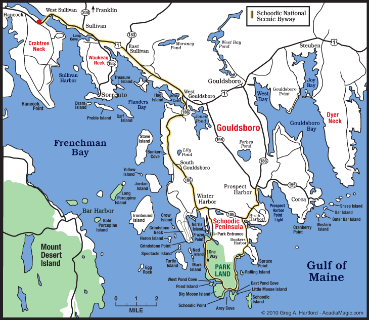
You can see Mount Desert Island in the bottom left of the corner.
The Schoodic Peninsula is the only portion of Acadia National Park on the mainland. Much of the peninsula was once owned by John G. Moore, a Maine native and Wall Street financier. In the 1920s, Moore’s heirs donated the land to the Hancock County Trustees of Public Reservations with the stipulation that the land be used as a public park and for other uses, including the “promotion of biological and other scientific research.” In 1929, legislation authorized the National Park Service to accept land on the Schoodic Peninsula as an addition to the park and changed the name of the park to Acadia. Soon after the law’s enactment, the Hancock County Trustees of Public Reservations donated the former Moore property (2,050 acres) to the National Park Service “for the public good and for the extension or improvement of said park, forever.”
In the 1930s and 1940s, some of this land was transferred to the U.S. Navy for use as a radio communication station. The U.S. Navy operated the base until the land was transferred back to the National Park Service in 2002.The former base has become the Schoodic Education and Research Center, one of 17 National Park Service research learning centers across the country. The center facilitates research projects throughout Acadia National Park and provides opportunities for learners of all ages to discover the park’s natural and cultural resources. (excepted from NPS brochure...they said it better than I could :-)).
We had wanted to get the dogs out for some walking, and there are four different trails on the peninsula in the park. We need the milder trails now for Chelsea (her arthritis is hampering her a bit), so after looking at the guides, we thought the Alder Trail and Schoodic Head trails wouldn't be too hard for her. First up, though, was a drive on the six mile one-way road scenic drive around the peninsula, with a stop at Schoodic Point to gather a couple of caches.
There's a plaque at the parking area dedicated to John G. Moore.
Schoodic Point is a wind-swept rocky point of land, with the evergreens and plants leading down to the edge.
Close-up of the green carpet on the rocks. I can't find what they are though, if anyone knows.
The cache we came here to collect is actually an earth cache; real caches are not permitted on National Park property, so caches have to be "virtual". The cache here was to teach us about "diabase dikes".
The granites of Mount Desert Island are approximately 420 million years old. Because their mineralogy is so similar, the granites are identified by the size of individual mineral grains and the composition of the scattered dark minerals present. One of the oldest granites to appear was the Cadillac Mountain Granite, the largest granite body on the island. It oozed up through existing rocks, stressing and fracturing the overlying bedrock and causing large chunks to fall into the molten magma body. Some chunks of bedrock melted in the intense heat, while others were suspended in the magma. When the granite cooled deep in the earth, these blocks remained, surrounded by crystallized granite. This region of granite and broken rock, called the shatter zone, is still visible on the eastern side of the Cadillac Mountain Granite. A medium-grained granite formed to the west of the Cadillac Mountain Granite. Later volcanic activity injected diabase, a fine-grained, black igneous rock into the granites and surrounding rocks. These diabase bodies, or dikes, can be seen along the road to the summit of Cadillac Mountain and on the Schoodic Peninsula.(from US-Parks.com geology page).
It was interesting to investigate this geologic formation, which I hadn't noticed before!
One last look before heading to the trailhead.
Even the parking areas have beautiful views.
The Alder Trail started off quite innocently, through beautiful grassy trails.
We entered the wooded area, and came to the crossroads where we could either turn back, or continue on the Schoodic Head Trail that climbs up to the summit of Schoodic Mountain. We figured we'd keep going, Chelsea was doing ok.
The trail turned a bit rougher, and we were doing ok, although stopping to catch our breath. But we reached a bridge over some water, and had to thrash around for the trail for awhile. We did find it, but it was going to involve quite a bit of rock scrambling, and large steps, and we felt it wasn't worth risking injury to Chelsea, so we headed back down the way we came.
Out in the cove by the parking area was this little island covered by gulls. They were quite noisy!
We noted on the map that there was a gravel road that went to the summit, and Chelsea thought that was a much better idea than walking up :-). This is the view from the summit looking towards Mount Desert Island.
Another nice day in a different section of the park came to a close. It's hard to believe we now have less than two months left here before its time to move on. Its time to make a list of the "must see places" and "must do items" before out time is up :-).


Great post. Thanks for all the background information. I can't imagine owning that much land. So thankful they were so generous with it. Tax incentives?? That looks like a trail we would like. Hope Chelsea was no worse for the wear.
ReplyDeleteisn't it just such a great place. . .loved it!
ReplyDeleteThat summit picture is amazing! Now, if you could just bottle that beauty and bring it with you...
ReplyDeleteGreat reading...I love your masthead of harbor boats!
ReplyDeleteBox Canyon Mark