Welcome to our Adventure!

Al and I are thrilled that you have found your way to our blog. We hope you enjoy reading our journal and viewing our photographs of the natural wonder of our United States of America. Let's hit the road together!
Homer, Alaska

Wednesday, June 29, 2011

The Legend Lives On....


The legend lives on from the Chippewa on down
of the big lake they called "Gitche Gumee"
        The Wreck of the Edmund Fitzgerald
Gordon Lightfoot 1976

The next day we set off on our adventure to the U.P. Our first stop was the city of Sault Ste. Marie, on the Michigan/Ontario border. Sault Ste. Marie is an ancient (by American standards) city, with the Ojibwa (Chippewa) Native Americans living there for over 500 years. In the 1600's French missionaries founded a mission there, making it the third oldest city west of the Applachians. Because of the location between Lake Superior and Lake Huron, it became an important center for the fur trade. After the War of 1812, and the completion of the Erie Canal in 1832, settlers from the East began to pour into the region, and shipping was becoming ever more important. However, the 21 foot drop of the St. Mary's river between Lake Superior and Lake Huron was a major obstacle to shipping. First ships and their cargo were being portaged around the rapids between the lakes, and as ships became larger, just the cargo was removed from ships at the top of Lake Superior, portaged around the rapids, and reloaded onto ships on Lake Huron. The process took weeks, and was becoming unmanageable, and so, in 1855, the first American lock, the State Lock, was finished, vastly improving shipping capabilities on the Great Lakes.

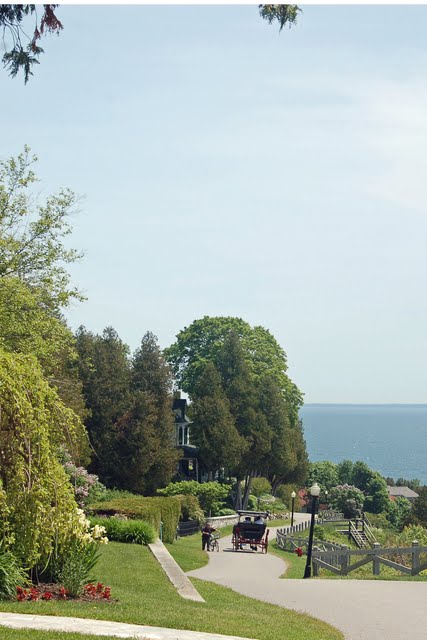
This brings us to the major attraction and reason for us coming here. The "Soo Locks".  The State Lock was operated by the state of Michigan until 1881, when it was turned over to the Army Corps of Engineers, who operate and maintain the locks to this day.  There are now four locks, the MacArthur and Poe locks being active at this time, with the other 2, the Davis and Sabin locks, closed for renovation work. The 2 active locks handle an average of 10,000 vessels a year. The Soo Locks are widely considered as one of the great engineering wonders of the world and is still the largest waterway traffic system in the world. What's even better is the wonderful Visitor's Center, with a museum dedicated to the history and statistics of this marvel, and a three story observation platform allowing you an up close and personal view of the ships entering and leaving the locks.  

We arrived at the Visitor's Center around 11am. The dreaded "No Pets" sign was up, so Al went in to scope out the situation. He came back and said the museum was great, and that there were three ships currently on their way to the locks, with the first supposedly arriving around 11:45am. It was a cool day, and we were parked in the shade, so we took the dogs for a quick walk, cracked open the windows, left them water, and told them we'd be back shortly. They're so good! :-). 

There were quite a few exhibits in the museum, showing the history, current usage, and future plans for the locks. There's also a movie, but we didn't go in to see that as the ships were due to arrive soon. There's live cameras posted inside the Visitor Center showing the ships as the steam their way up or down the lakes, and the Visitor Center hostess keeps the timetable updated as to the ships arrivals to the locks. 


This is an aerial view of the American locks.


An exhibit showing a model of the Edmund Fitzgerald


The administrative building at the south end of the lock, leading into Lake Huron


The U.S. Hydroelectric Plant. The water not used in the locks is diverted from the St. Mary's River through this plant, which generates over 150 million kilowatt hours of electricity a year. Most of this is used to operate the machinery at the lock system, but the local power authority purchased the leftover and distributes it to local businesses and residences.


The first ship enters the MacArthur lock directly in front of us. The American Courage is sailing from Lake Superior to Lake Huron, headed for Gary Indiana with a load of iron ore. It needs to drop 21 feet from Lake Superior level to Lake Huron level.


The American Courage is being lowered in the MacArthur Lock, as the CSL Tadoussac is entering the Poe Lock. That one is also going down to Lake Huron. There was another Canadian ship coming up from Lake Huron, but they delayed that one for some reason, and these two came through first. In the background you can see the International Bridge, linking Michigan's Sault Ste. Marie to Ontario's Sault Ste. Marie. 


It was about a 30-minute process, and the American Courage was completely lowered, the lock gates open, and she was ready to head into Lake Huron. It was really very interesting to watch, and we were so fortunate to arrive when we did. After these two ships and then the Canadian ship coming up, there were no more scheduled for the day until after 5:00pm. Timing is everything!

We headed back to get the dogs, and after being given a good talking to by them :-), we had a quick sandwich, and headed back on the road to our second half of the day. We now headed west to Brimley State park, and the starting point for the Whitefish Bay Scenic ByWay. This drive is in just about every guidebook on travel that I have :-). Whereas many times we like to find "the road less traveled", in other instances the "beaten path" is beaten for a good reason :-). 


The beach at Brimley State Park, along the shoreline of Lake Superior. I can see why this is a very popular camping area in the summer...the beach is beautiful!


The obligatory stroll through the campground. As usual for Michigan State Parks, the sites are nicely spaced, huge firepits, electric only sites.


After leaving Brimley, we drove through the Ojibwa community of Bay Mills, where a few casinos were located, and followed the shoreline of Lake Superior. We stopped here at Iroquois Point Light Station, a 65-foot brick tower built in 1870, replacing the wooden tower that was built in 1857. The Iroquois Point Light Station was used for 107 years to warn ships of the tight fit through Point Iroquois and the rocky reefs of Canada's Gros Cap.


Picture perfect sky!


Gros Cap Canada across Lake Superior. Can you see the windmills on the mountain tops?


Taking in the view of Lake Superior


The drive follows the curve of Lake Superior, and passes through the vast lands of  the eastern unit of  Hiawatha National Forest. I will pause here and say if you are doing this drive, be sure you start from Sault St. Marie with a full tank of fuel, and snacks and drinks; the services, if you find any at all, are few and far between :-). We pulled off here, at a turn-out called "The Shallows". It was time for a stretch of the legs, and to see what the shoreline looked like here. We walked down this short path...
and this is what we found! Isn't it beautiful? There wasn't a soul anywhere to be found, the beach was flat and hard, the water so shallow, that Al decided it would be a great spot for Casey to let off some steam.


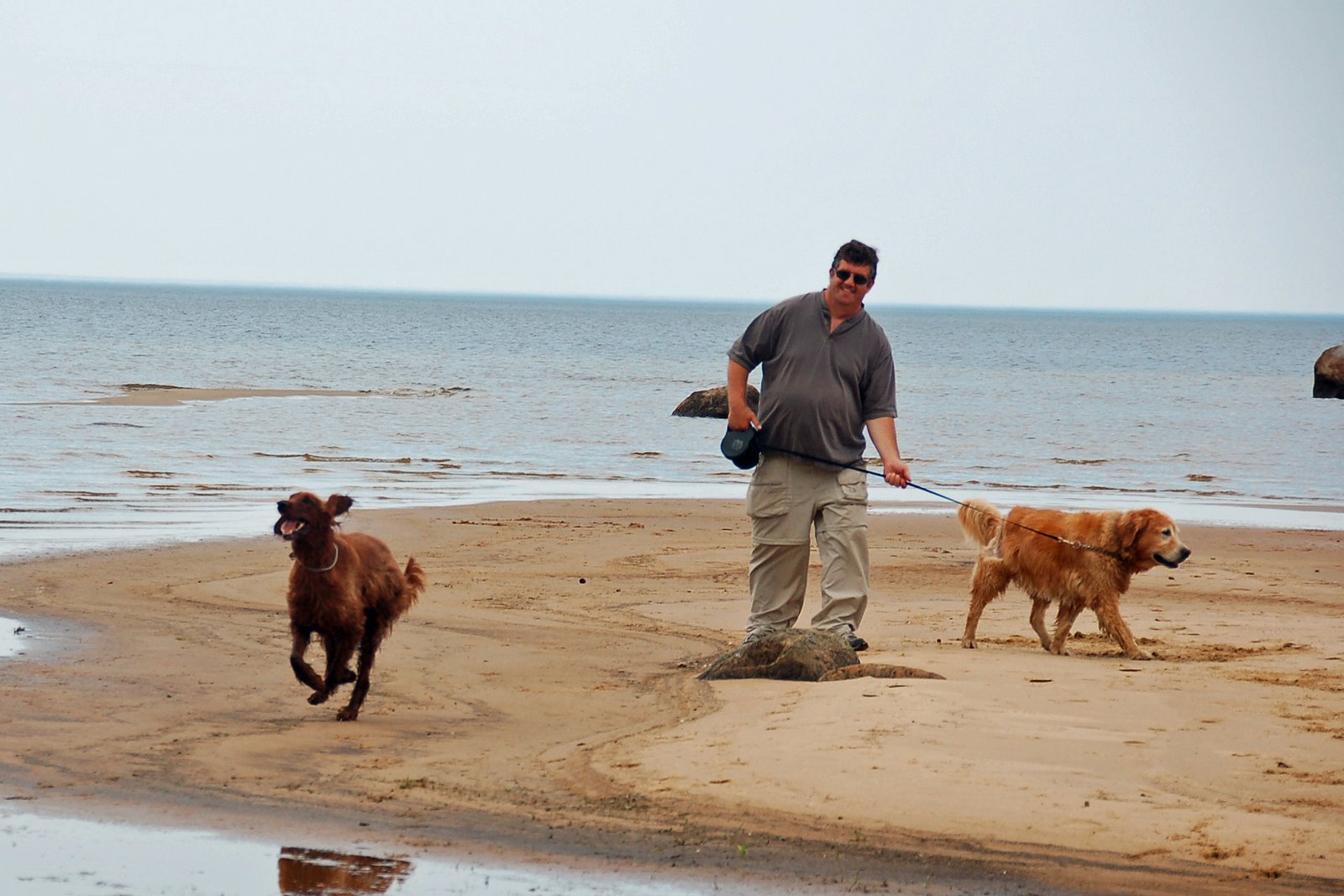
Just look at that face! Does he look ecstatic or what?


A long shot of Casey running along the shoreline.

I'm going to stop at this point, as I need to get ready to go to work. But we still have the Shipwreck Coast, Paradise, and Tahquamenon Falls State Park to finish off the day :-). Stay tuned!

Sunday, June 26, 2011

Mackinac Island Day

Ever since we announced last winter that we would be working in Michigan this summer, people in the know would tell us "you have to go to Mackinac Island". Since we've arrived, people ask, "Have you gone to Mackinac Island yet?" So, Thursday 6/17 was the day! It was a partly cloudy day when we set out, and on the cool side. Jeans and sweatshirts were called for! We arrived at Shepler's ferry terminal, and after double checking that dogs were allowed on the carriage tour, I bought combo tickets for the ferry ride and Mackinac Island Carriage Tours. The 9:30am ferry also took you for a ride under the "Mighty Mac" on the way over to the island.


Mackinac Island has a varied history, from American Indian summering grounds, to a center of North American fur-trading business, and a colonial fortress. It lies in the Straits of Mackinac, where Lakes Michigan and Huron meet, and where the Lower and Upper Peninsulas of Michigan are joined by the Mackinac Bridge. In the late 19th century, the clean lake air and beautiful views of the island started to draw a crowd of wealthy urbanites, and it's popularity grew as a summer playground. Locals banned the automobile from it's shores almost as quickly as it arrived, and to this day remains as a horse and carriage mode of transportation only. The island is now known as a living postcard for the Victorian-era of life.
We arrived to the island through the jetties marked by these 2 lighthouses.

View of the harbor as we arrived.

 The governor of Michigan's summer residence high on the bluff
Fort Mackinac is a military outpost built by the British in 1780. They believed Fort Michilimackinac on the mainland was too vulnerable to the American colonists, so they moved their base of operations to the island. Re-enactments and demonstrations are shown daily here, and the views from the ramparts are stunning.

Mackinac Island's most famous landmark, the opulent Grand Hotel. It was built in 1887, when rates for Michigan's tycoons were $3.00/night! The Greek Revival palace is believed to be the largest summer resort hotel in the world to this day. It has become known as the backdrop for the movie cult classic, "Somewhere in Time", starring Jane Seymour and Christopher Reeve.

Once on the island, we walked down bustling main Street to the carriage tour booth. Main Street was filled with kitschy stores, t-shirt shops, eateries, small hotels and of course, many fudge shops! It pretty much reminded me of downtown Sag Harbor on a summer day, without the cars of course! The girls loading the carriages offered us some water for the dogs, and then we loaded up in the rear of the carriage. Casey is on his best behavior, sitting up in his seat next to Al. he was very concerned about the horses however; I don't think he has ever been this close to one before!

The tour took us slowly through Main Street, through some beautiful lilac-laden streets ( it was actually the week of the Lilac Festival, and the smell was quite over-powering in some areas, but it was beautiful!), past the Grand Hotel, to the Surrey Hills Museum, where we dis-embarked this carriage to wander through the facility. Old carriages were on display, and there are several shops and snack booths here.

You can also visit the Wings of Mackinac Butterfly Conservatory for an additional fee, but we had to skip this being that the dogs were with us. It looks beautiful, though.
We then re-boarded different carriages, these ones the largest horse-drawn carriages anywhere in the world, holding over 30 passengers and pulled by three large horses.


On these carriages we rode in the front seat, as invited by the driver. He felt there would be more room up front for the dogs. This is a short video I took while driving through the State Park forest. Seventy-eight percent of the 2200-acre island is protected as state-park land.

After rolling through the State Park forest, we stopped here at Arch Rock, a natural formation on the shoreline of the island. There's an Indian legend about the formation, but it is geographically stunning. There's an observation walkway alongside, and we had our picture taken at the end:
Here I am again...I'm really here :-).
We returned to the carriage, and the tour ended at Fort Mackinac. You could depart here to explore the Fort (for an additional fee), return via footpath to the bluffs near Arch Rock, or return to town with the carriage. We elected to go back to the bluffs for more pictures.
The road running along the top of the bluff on the east side of the island

The view of the harbor from high above

One of the mansions along the bluff road

There's a boardwalk staircase down the bluff that takes you back down to the harbor side.

Another view of the jetties and lighthouses, framed by lilacs


A video of Main Street activity

Time for lunch at "Chill'in and Grill'in"! We selected it mainly because it had outside seating where we could sit with the dogs, they were very friendly and gave us bowls of water and treats for them, and it was very tasty! I had a chicken/bacon/cheese ranch wrap, and Al had the whitefish burger. I definitely recommend it, and the harbor view is awesome!
Once lunch was over, time for a walk. There are several walks on the island, and we covered a lot of the spots on the carriage tour. So we decided to explore the west bluff of the island for our walk. There is also an eight mile road encircling the island which is great for bicycling, but whereas Casey would be fine jogging along with us, I don't think Chelsea is up for it anymore!

Down a quiet side street

Cute little stone church

View of the bridge across the park

Another view of the front of the Grand Hotel. The views from the 660-foot long front porch must be spectacular, but the hotel now charges $10.00 per person for tourists to enter the property. Apparently the guests paying large sums of money to stay there were getting miffed at the hoards of tourists descending upon the hotel, so they needed a way to cut down the crowd. I'm sure it was nice, but there's beautiful views elsewhere on the island, I didn't need to spend the $$$'s there!

The golf course across from the hotel.

There were wild orchids, or "lady slippers" blooming in several spots on the island. We used to have pink oneson the east end of Long Island, but I haven't seen any since I was a kid and my grandmother would take me for a drive in the woods to find them.

 
A trail along the west bluff, and more beautiful homes


Wildflowers and lilacs along the bluff

A wooden staircase leading down from the bluff to the lakeshore road...we were really hoping it would take us back to town, as that stairway would have been a real bear to go back up!!

The quiet road around the island

 
The shoreline

The Round Island Lighthouse, built in 1895. The beacon was replaced by an automated light in 1924, and then the lighthouse was abandoned when a new one was built in 1947 near the breakwater on the south side of the island.

The Hotel Iroquois, with some brilliant red geraniums, at the west end of Main Street.
It was now late afternoon, so time for some light shopping, the obligatory fudge stop, and a return to Mackinaw City on the ferry. The wind had picked up considerably, and it was a wet ride for people on the other side of the ferry; fortunately for me, I travel with a fisherman, and he determined the dry side of the boat to sit on :-).

When we arrived back on the mainland, it was time for some ice cream, and then we made the short drive to Wilderness State Park. It's a scenic 11 mile drive along the Lake Michigan coastline, to Sturgeon Bay. There's 2 campgrounds in the park, one on the lake with beautiful views, and one in the forest. There were a couple of spots where we could take a short walk, but the main hike along the beachfront was closed due to the Great Lakes Piping Plovers nesting in the area, and the dogs were definitely not allowed. It was a pretty park, and felt quite remote, but I will say at dusk when we were there, it was quite buggy. You wouldn't want to be camping without your insect repellent!


Back at the motel, it was time to settle in, have some dinner, and get ready for the next day's adventures in Sault Ste. Marie, and the Shipwreck Coast.