Don't worry, the promised blogs on Moab with two National Parks, Arches and Canyonlands, is still coming. I thought I'd update you as to where we are at this moment and what we're up.
Tuesday, May 20, was a travel day for us from Torrey UT to Moab UT. I think it was our shortest hop since we left Florida, just about three hours. It was a great drive back through Capitol Reef. Just as we drove through the town of Moab, I noticed Al was going pretty slow, even though it was through the busy area. His flashers came on, and he radio'd me that he was losing power, and the truck was not running right. We did make it the mile to the campground, and got in a site. There is a Ford dealer right in Moab, we passed it on the way, so he went right down there. They couldn't look at it right away, but told us to bring it down on Friday. Can do.
We proceeded to get hooked up, and I heard some unmentionable language from the driver side, Apparently water had started pouring out of the filter system when Al turned on the water. For whatever reason, the gasket had come loose during travel. After some fiddling with it, back in place and good to go. As I was putting out the slides, I noticed during travel the recliner had once again sprung up, but knowing it has a tendency to do this, I only open the slide a teeny bit so I can shimmy down there and check it before opening it fully. So, it wasn't a great start to the week in Moab.
Thursday we went to Canyonlands, a pretty good drive out to the end Of the Island in the Sky district, when I noticed the back tire of the TB looked a bit low. As Al was getting out the pressure gauge, I found a screw stuck in the tire. Geez! Of course, we have all our hiking and picnic gear in the cargo area that needs to be taken out to get at the equipment to change the tire, but we got it all done, spare put on and off we went. Looks like Friday is going to be a mechanic day!
So Friday we ended up with four new tires on the TB (it was determined that they were pretty much on their last legs anyway), as well as an oil change. Of course, the truck ran fine going down to Ford, and the diagnostic computer didn't pick up that anything was wrong. Figures. So that got an oil change and a new fuel filter. Expensive day. But wait, it gets better!
As Al was dumping tanks Monday night in preparation for us leaving Tuesday morning, he sees a drip coming from the bottom of the coach. In the vicinity of the black tank. OMG please don't tell me we have another cracked black tank! We figure we'll be at our home spot for the summer on Wednesday, so once we're there, he'll drop the belly panel and see if he can figure out what is going on.
Tuesday we hook up, and with a few prayers and everything crossed, we take off. We're headed for Evanston WY for one night, then a short three hour ride to Luton's Teton Cabins in Moran, WY where we're working for the summer. The truck runs great, all through Utah, starts fine after each stop, and we're slowly breathing a sigh of relief, and enjoying the ride. Once we got past the town of Price, UT the scenery became awesome, and we started seeing green again! Lots and lots of green grass :-). Through Salt Lake City, then Park City, and into Wyoming. Evanston is just several miles into the state, and we pulled off the highway to the campground for the night, Phillips RV Park. As I got out of the TB to check in at the office, I hear Al revving the engine, and a dreaded knocking sound coming from it. He said it just started as we exited the highway. I looked up Ford dealers in the area and saw one less than a mile away. Whew! We never turned it off, just unhitched and he went straight there. Back in five minutes; it's no longer a Ford dealer. Ugh. The recommended the closest one.....over 30 miles away.....double ugh. So we fired up the laptop and started looking. We called the first one....can't really deal with the diesel trucks. They recommended Park City. They can't look at it until next week. There's a Pilot truckstop a couple miles away, so he went down there to see if they can help or recommend someplace. They can't, and the local diesel mechanic they recommended said he couldn't do it. We're getting quite frustrated at this point, if you can imagine. Finally, a Ford dealer in Morgan UT will take a look at it Wednesday. He didn't recommend driving it there though. Now, we have to get it there!
Off I go to call Good Sam Roadside Assistance. I am happy to say, once again, we had a good experience. Within an hour a tow operator arrived at the campground with a flatbed, and took our poor truck off to Morgan UT for the night. At that point, all we could do is wait for them to run a diagnostic and we'll see how bad it is. The error codes were showing a fuel injector issue. At least this time there is a code that something is wrong!
We called the service department first thing this morning to let them know, if they didn't see it, that the truck was there and to throw ourselves on their mercy to get a diagnostic done quickly so we can make a game plan. We are supposed to start work on Sunday. We need to figure out how we're going to get there in case of the worst case scenario...which I always plan on! Dean from service promised to call us as soon as he knew anything. In the meantime, I went and paid for two more nights, we made some calls, and figured if we're stuck here, might as well clean the coach good. So we tackled that.
Well Dean did call a couple of hours ago and the news is not good. As readers of RV Dreams will recall, we have a "Howard and Linda" situation. When they started the engine and opened things up, they found we are having blow-by in the crankcase. This means a new engine. Right now we are waiting on more calls that have been put into Ford as we have their extended warranty. I'm grateful for that, but am antsy waiting to hear what they will cover. Reading through the contract we believe the majority if not all should be covered. In the meantime, we're also waiting to hear "how long", as we may have to hire the towing company to take the coach up to Moran for us. We're very happy we have the TB with us at this point.
Oh and the leak? Al pulled everything out of the basement this morning, and took off the partition wall between it and the inside workings of the coach. He figured that might be an easier spot to start rather than taking down the belly cover, and he is happy he did. He found water leaking from the hose connection to the hot water heater, and there was quite a bit of water dripping down. He followed its path and found it was running over an edge and into the belly, where it was probably leaking from the bottom where he saw it. He tightened everything up, cleaned up the water mess and now will keep an eye on it to make sure that was the only issue.
Are we frustrated? Yes. We were getting very upset last night when we couldn't get anyone to help us. One of the hazards of traveling like this is that things may go wrong when you're not really close to anything. I'm glad I have roadside assistance, and feel very lucky that the first year on the road we didn't have one and nothing happened. Once things got moving, we felt like we could take a deep breath and look at the scenarios. But it is sheer panic when you realize you have a BIG problem, and you're not sure where to start. We will get through this as we have so many other things. Stay tuned...and I will be getting more nice pictures up soon!
After posting update: Dean from Young Ford called us and said the extended warranty will cover the new engine (thank you Lord) and it should be ready by the end of next week. If all goes well.
Wednesday, May 28, 2014
Monday, May 26, 2014
Bryce Canyon National Park
"Before there were any Indians, the Legend People, To-when-an-ung-wa, lived in that place. There were many of them. They were of many kinds-birds, animals, lizards, and such things-- but they looked like people........For some reason, the Legend People in that place were bad. Because they were bad, Coyote turned them all into rocks. You can see them in that place now; all turned into rocks; some standing in rows, some sitting down, some holding onto others. You can see their faces, with paint on them just as they were before they became rocks.....This is the story the people tell."


-The Paiute Indian legend of Bryce Canyon as told by Indian Dick
Bryce Canyon National Park was simply amazing. I feel I need a thesaurus as I have been overusing words like amazing, beautiful, glorious and wonderful. But it truly is.
It was a three hour drive to Bryce from our campground, but we decided it was going to be worth the six hour round trip. Besides, the entire drive would take place on National Scenic Highway 12, by all rights a destination unto itself. So we got up early, and headed on down the road. The ride was awesome, and the time flew right by. We stopped at the Escalante Interagency Visitor Center, for a rest break, stamp our passport book for Grand Staircase-Escalante National Monument (remember we hiked Calf Creek Falls so we did participate in an activity in the area), and there's also a great information booklet for Highway 12 that I picked up. Just a little under three hours we pulled into Bryce Canyon Village at the entrance to the National Park. This is where the famous Ruby's Inn Bryce Canyon is located, and I believe almost everything in the area belongs to Ruby!
We stopped at the Visitor's Center to collect maps, information and create a game plan for our visit. There would be no hiking this trip once again, as we had the dogs with us (way too long a time for us to leave them by themselves), so we wanted to see what we could do and the best way to see the high points. The road through the park is 18 miles long, with most of the overlooks on the left hand side going down to the end. It was suggested the best way to go was to drive all the way to the end, Rainbow Point, and then work your way back so you would always be turning to your right, rather than across traffic. So off we went to Rainbow Point.
This is our first view at Rainbow Point. It's interesting to note that Bryce Canyon is not actually a canyon at all. It has no great river running through it to carve the landscape, but instead is a series of amphitheaters carved into the edge of the Paunsegunt Plateau. In these natural amphitheaters are the beautifully carved and colorful erosional forms called "hoodoos" which makes Bryce unique.
On Rainbow Point is a grouping of Bristlecone Pine trees, the oldest single living organisms known, with some individual tree being more than 5,000 years old! The Bruce Canyon bristlecones are mere youngsters, estimated at about 1,800 years old. Can you imagine??
Yovimpa Point: the Pink Cliffs. These are considered the "top step" of the Grand Staircase. You can read about this staircase here.
Ponderosa Canyon. An excerpt from The Auto Guide I picked up:
1916: a conversation between cowboy Claude Sudweeks and new settler Ruby Syrett:
Claude:"Ever seen Bryce's Canyon?"
Ruby:"No, what is it?"
Claude:"Oh, just a hole in the ground--but you should see it".
Before becoming too critical of the often casual attitude toward Bryce Canyon by many of its settlers, put on their shoes for a moment. "Our grandparents were thrilled with its beauty...but they could do little about it. They were too busy trying to make a livelihood for their families. There were no roads,just poor trails. Their wagons were worn out, their horses or ox teams were poor and unable to make many trips, save for the bare necessities."
Agua Canyon: do you see a bunny?
Natural Bridge. Despite the name, the 85 foot span seen from Natural Bridge viewpoint is believed to have formed without the aid of running water, making it an arch, not a bridge. Runoff water from the adjacent rim eroded the softer sandstone under the harder sediment above, creating a gully and the arch above.
Farview Point.
Pronghorn
Paria View overlook. The scenery is getting more fantastic the further north we drive along the road. But the main event is coming!
Bryce Point.
The details are amazing.
A walkway goes out along the rim,surrounding you in a fantastic immersion on three sides.
Then, we finally reached Inspiration Point. A very steep walkway up to the point, but oh so worth it!
Called "The Silent City", it appears as a tightly packed cluster of hoodoos. Actually, it is a series of closely spaced gully walls, some of which are more than 600 feet long and 200 feet high. Numerous secondary walls branch off the main gully walls, adding to the appearance of density and making the area literally a maze of false passageways.
Sunrise and Sunset Points were our final stops before leaving the park for our three hour return trip to Torrey.We completely enjoyed Bryce Canyon National Park, and look forward to returning again one day, staying closer so that we can take in some of the hikes and really immersing ourselves into the geology.
This brings a close to our adventures in the Capitol Reef National Park area. We have moved onto Moab, UT and will be visiting Arches National Park and Canyonlands National Park, so don't go too far!!
Saturday, May 24, 2014
Off Highway Fun and Goblins
Having our SUV with us this year, a Chevy Trailblazer (TB), has made a good difference in our travel so far this year. It is saving many miles on the Ford F450, our tow vehicle, which will hopefully make it last longer for us. The TB is also much easier to drive around town and parking is much easier to find as well. It is also a 4WD vehicle, and while it isn't outfitted with lifts or anything like that, we are still able to do some milder off-road adventuring that we really didn't like to do with the truck.
While here in Capitol Reef, there is a driving loop tour comprised of the Notom-Bullfrog Rd, the Burr Trail Road and then Highway 12 back to Torrey. We decided to try it out and had very good success :-).


While here in Capitol Reef, there is a driving loop tour comprised of the Notom-Bullfrog Rd, the Burr Trail Road and then Highway 12 back to Torrey. We decided to try it out and had very good success :-).
Notom-Bullfrog Road was about a 20 minute drive east from our campground. It runs parallel to the Waterpocket Fold on the east side, and allows access to many trailheads and scenic features in Capitol Reef's southern district.
Casey was ready for the day's adventures!
The first 6 miles or so are paved then turn to dirt roads. Easy driving, just a tad dusty. The Waterpocket Fold's buckle is the uplifted slabs starting at the right side of the picture and heading around in front of the road. The road does curve and follows the buckle.
On the left side of the road were these dunes, and yes it was crusty sand; Al and the pups got out to investigate while I was taking pictures.
Close-up views of the buckled earth.
We arrived at the junction with Burr Trail after about 30 miles. You can continue the Notom-Bullfrog Road all the way south to Bullfrog Marina on Lake Powell or turn off onto Burr Trail as we did. However, we had to get from way down here to way UP there! Remember, the west side of the Fold is 7000 feet higher than the east side.
Climbing the switchbacks....really glad I'm not hiking this!
Looking back down to where we started from.
Up on top and we are in real red country now! We find a quiet dirt road and drive down, looking for a spot to have lunch...this was our view, not so bad eh?
Burr Trail is named after John Atlantic Burr. His family had settled in Salt Lake City, and he moved south where he established the town of Burrville UT in 1876. He developed a trail through this nearly impassable country to move his cattle back and forth between winter and summer ranges and to market.
Once back in Boulder on paved roads, you follow Scenic Hwy 12 up and over Boulder Mountain returning to Torrey. As we got down the mountain, we were feeling the need to stretch our legs and I read of a short trail to a waterfall at the back of Singletree Campground, a National Forest campground. So we swung in, found the camphost (very pleasant) and he directed us to the trailhead. It's a primitive campground, no hookups, but really pretty, quiet and had nice sized sites, even for larger rigs, so if anyone out there is looking for this type of place, I recommend it.
The camphost had told us if was a short 1/2 mile hike to the falls; information that was not given to us was that it was a 1/2 mile STRAIGHT DOWN, meaning the return was a 1/2 mile straight up! We managed, even at over 8000 feet, although it took me a little longer than I would have liked :-).
The reward; not truly spectacular, but at least there was a waterfall!
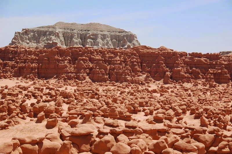
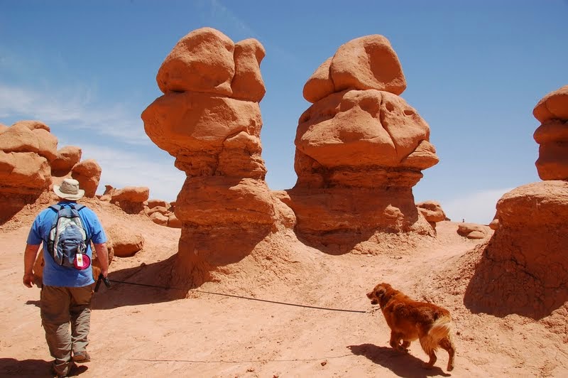
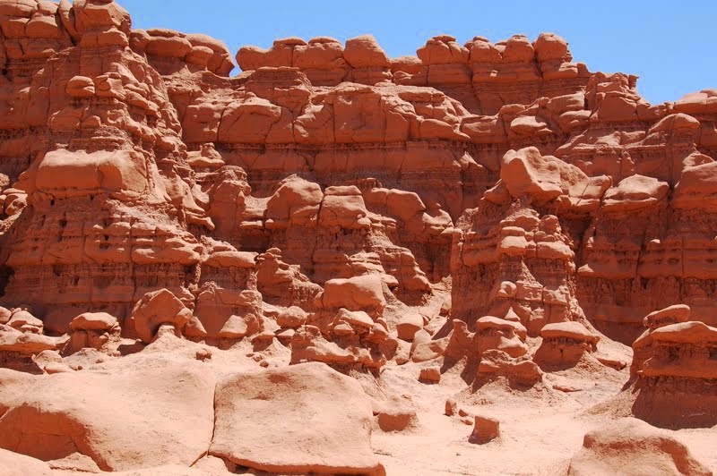
A different day we took a drive to the unique Goblin Valley State Park.
Goblin Valley is an area where the soft sandstone has eroded into truly individual shapes, said by some to resemble goblins.
Several areas have many goblins close together, creating a maze-like arena where you can wander around at will.
With it's somewhat surreal appearance, Goblin Valley was selected as a site to film scenes from the movie "Galaxy Quest".
The official term for these structures is "hoodoos"; a hoodoo is a tall, thin spire of rock protruding from the bottom of an arid drainage basin or badland. Hoodoos can range from 5 to 150 feet tall, and consist of relatively soft rock topped by harder, less easily eroded stone that protects the column from further erosion.
Goblin Valley State Park is the site of the infamous toppling of a hoodoo by three Boy Scout leaders last year.
Now, remember the term "hoodoos" for the next installment of our adventures here in Utah....a day trip to the beautiful Bryce Canyon National Park!
I have uploaded all my pictures of our adventures in Utah so far to my Flickr account. If you would like to see all pictures to this date, go to: https://www.flickr.com/photos/22321510@N02/sets and click on the Capitol Reef National Park album.
Tuesday, May 20, 2014
Lower Calf Creek Falls
After our day of scenic driving, we decided it would be a good idea to get our blood moving and get the dogs out for a walk. Investigating the possibilities in the area for dog-friendly hikes, I found Lower Calf Creek Falls recreation Area, in the Grand Staircase-Escalante National Monument lands. As with other National Monuments, it is dog-friendly on the hiking trails so long as they are leashed and picked up after. No problems there, I wouldn't consider letting them loose anyway! The hike is 6 miles round-trip, and rated as "moderately strenuous" due to the sandy soil you would be walking in for several stretches. The objective is to reach one of Utah's prettiest waterfalls, 126 feet high, as you hike through a gorgeous canyon with mineral-streaked cliff walls, beaver ponds, cottonwood trees and prehistoric rock art sites. Shall we begin?


We arrived at the parking area about 10:00AM, after an hours drive from our campground. There is a small primitive campground here, but not for rigs any larger than 23 feet...or at least that is what the sign suggested! We changed into our boots, loaded up water and lunch into the backpacks, and off we went. Average hiking time was estimated as 2 hours each way, knowing us it will be longer :-).
Its always nice to see the dog-friendly sign! There is also a box with trail guides here, showing the trail as well as 13 interpretive stops along the way.
Most of the trail was completely exposed to the sun, so sunscreen and hats were a necessity.
These were the noted pictographs on the interpretive guide. They were very far away, the other side of the canyon, and you could still see them. They are completely different from the style of pictographs we saw further south in New Mexico and Colorado.
Walking, walking walking....finally we hear voices and the sound of water ahead....
Finally! We arrived. And it is wonderful. It had gotten quite warm walking in the full sun but here in the shade of the canyon's end, and the mist of the waterfall it was nice and cool. A beautiful spot for lunch and even though we weren't alone, it was still wonderful.
Casey and Honey went straight into the water splashing and having a great time fetching sticks.
After lunch was a very good time to catch a nap and rest up for the return trip back up the canyon.
I scooted all around the grotto taking pictures from all angles, while waiting for people to move away from the edge so I could get a clear shot, but my light was starting to go away as the sun was starting to hide behind the high cliff walls. I liked how the green plants are hanging along the walls of the cliffs.
I finally got to take a picture directly in front of the falls even though the shadows are lengthening. You can see the perfectly symmetrical pool at the base of the falls. I think this is my favorite picture.
Finally it was time we put the backpacks back on and head back down the trail. I had been hoping the trail would be more shaded on the way back....
Oh well it wasn't!
I think this is a Bullock's Oriole who posed so nicely for me.
Finally we made it back to the red rock stairs leading back off the trail to the campground. We spent almost 6 hours between hiking and visiting the waterfalls. We were all tired but very happy we were able to experience it. It is considered one of the most beautiful hikes in Utah, yet accessible to a vast majority of people. You won't be alone doing it, as it is very popular and highly known, but I think it is a gem not to missed by anyone traveling through the area.
Next up: an off-highway drive making a loop through the Waterpocket Fold, the Burr Trail to Boulder and back down Scenic Highway 12....and another waterfall!
Subscribe to:
Posts (Atom)