Welcome to our Adventure!

Al and I are thrilled that you have found your way to our blog. We hope you enjoy reading our journal and viewing our photographs of the natural wonder of our United States of America. Let's hit the road together!
Homer, Alaska

Sunday, September 30, 2012

The Waiting Game

And so we wait. And wait. And wait.

Who would think that we'd be complaining about weather in the low 80's, no humidity, and sunny? Go figure. But that is much too warm for harvesting the beets. The temperatures must be between freezing and 70 for proper harvesting. And so we wait. The "perfect" forecast we had coming up is slowly going downhill as well. The last message we had on the "beet hotline" said they hoped to start Monday or Tuesday. Looking at the ten day forecast, Thursday and Friday nights show temps in the 20's...so we wonder if we'll be shut down those nights due to cold? This is where more detailed information about the job would have been helpful. It's doubly frustrating as Amazon called last Wednesday to see if we could come....now?! We've already signed the hiring paperwork here, and done the training, so we don't want to leave...but knowing we'd be working there while twiddling thumbs here is annoying. Oh well, it's a new experience and I know many of you are looking forward to hearing about it!

Unfortunately, there isn't too much to do here, except watch sugarbeets, soybeans and hay grow :-) We did find a Ford dealer in Fargo and went yesterday to have the truck serviced, oil, fuel filter, and it was due for a 90K transmission tune-up. That was an ouch, but due diligence on maintenance will hopefully keep us trouble-free down the road. The truck is our life blood after all...without it we wouldn't be going anywhere!

While in Fargo, we visited the Fargo-Moorhead Visitor Center.
This painted bison was there to greet visitors. I didn't take pictures, but while in Custer, there were many painted bison decorating the streets of the business district. It was really neat, and reminded me of the decorated frog sculptures in downtown McKinney, TX when we were visiting Al's family there.


The Visitor Center is home to one of Fargo's most famous citizens, The Wood Chipper from the movie "Fargo". This movie is really all I knew about Fargo, and it was enough to make me stay away from wood chippers :-).
The Wood Chipper in person

and up close! Yes, this is what we are doing for some excitement :-). I wish I had a copy of the movie to watch, it's been so long since I've seen it. After saying hello to The Wood Chipper, we headed down the road to pick up a few things at WalMart, since we were "in town", and then had lunch at one of our favorite places, Culver's Butterburgers. We discovered Culver's in Michigan, and you can't beat their burgers or frozen custard. Yum!

One nice thing here is there is a very nice public park, Woodland Park, here in Hillsboro. It's usually devoid of people, so we can let the pups off leash and have a good game of wingy ball with Casey. Chelsea just likes to roll around in the grass :-). Then we go for a walk around the perimeter roadway. I don't know if it's because we became acclimated to a higher altitude, or got in better shape climbing all those trails, but walking here is a snap! I almost feel like I could jog ( I can't believe I just said that!). So we go to the park twice a day right now. We've been catching up on some television shows, I started beading a new bracelet, and Al has been working on a new model rocket. Not very exciting stuff, but there you have it.

Today I'll leave you with a picture of some of the, shall we say, interesting things we are finding up here in Hillsboro Campground. Has anyone ever seen a rig like this before, for real?? I assure you, it is real, and there is a family living in it. They are here for the harvest. Too funny!

Hopefully, I will have a better idea of what's going on after Monday. We feel we have made a commitment to work here, and don't want to be "those people" that leave, but jeez, it sure is frustrating to be sitting here. I'll be back when I have something to report :-)!

Thursday, September 27, 2012

Badlands and Beets

We have arrived in North Dakota as of Sunday evening. A long drive, and the sight of huge rolls of hay will be my first thoughts of North Dakota from now on. Lots and lots of hay up here! Monday morning we checked in with the representative from Express Employment, our recruiter, to do the hiring paperwork and view the orientation video. From there we were sent out to the Hillsboro site for training. We have been assigned to the Reynolds site, about 20 miles from the campground, which isn't too bad. It's farther than I would like to drive, but its better than the Ada site which is 40 miles from here! Campgrounds are few and far between out here. In fact, it is mostly farmland as far as the eye can see. Even the closest WalMart is 45 miles south of here, in Fargo. So we have stocked up for as many days as our fridge and pantry can hold, as once we start there won't be much time for shopping.

Tuesday we went back to the Hillsboro site for a full day of hands-on training on one of the piler machines. This is where we will be working. The piler is where the trucks full of sugarbeets come to unload their product. They pull in to either side of it, and then dump their trailer of beets into a hopper, where a conveyer shuttles them through the piler. While this is happening, my job is to go over to the driver, and collect his paperwork. The paperwork will tell me whether a sample is to be taken of his load. If yes, then I go over to the sampler, place a bag on the funnel, and hit "sample" button. A bucket then scoops some of the beets up and deposits them into the bag, which I then seal up and place in a collection area. While the beets are being shuttled along the conveyer, they are being shaken and sprayed down to remove the dirt from them. The company doesn't want to pay for the dirt as well as the beets! Once the load has been deposited, I then direct the driver to park under another conveyer, which will take the dirt that's been removed from the beets and return it into the bed of the truck. I then signal the driver he's clear to take off, and his truck is re-weighed at the scale house to determine the weight of the crop he just dropped off. Al was working with me for awhile, and then was "promoted" to pile operator...he actually worked in the control room of the piler. All in all, it wasn't rocket science, and once we got down the steps and I figured out how to grab the pencil stub for filling in the ticket with my gloves on, we were good to go :-). Now we're just hanging out, waiting for the harvest to officially begin, which supposedly will be October 1. It all depends on the weather, though. The temperature needs to be between freezing and 70 degrees, otherwise they can't harvest. Rain will also shut it down. We have heard, though, that the long-range forecast is pretty good, and that the harvest should be done within 2-3 weeks tops. That's a good thing, as I don't really want to work at this pace for too long. Its not hard, but the shifts are long, 12 hours, and go every day that the weather is good. And we've been assigned to the night shift, which is what we requested, as we feel the dogs will be better off cooped up in the trailer overnight by themselves, rather than during the day.

Well, enough about that for now. How about some pictures? We spent two days in the Badlands National Park before heading this way. Very interesting place! I felt as if I had driven right into a moonscape of some kind. When we left Custer, we drove east towards the town of Interior, where we stayed at the KOA Badlands/White River campground, and elected to ignore the gps telling us to take the interstate. We drove through the Badlands on Highway 44, and it was really neat. After getting set up (it had only been a 2 hour drive), we drove up to the town of Wall, to see the famous Wall Drug and find a grocery store. Definitely a tourist trap, and quite full of kitschy items. Actually, I'm glad we needed to find a grocery store and fuel, as Wall Drug itself really wasn't worth spending the 40 miles worth of fuel on by itself :-)!!

We did drive the Badlands Loop road back to the campground, and being later in the day the colors just seemed to pop from the formations.


The Loop Road roughly follows the Badlands Wall, a 60-mile long line of buttes that dominates the surrounding terrain. The story of the park's geology begins with shale that was deposited about 70 million years ago, and can be seen as a blackish layer at the bottom of some formations. Above that are layers of sandstone, volcanic ash, ancient soils and siltstone in shades of yellow, gray, brown and red. 

The Yellow Mounds

The strata is clearly visible in these formations.

We walked a few trails in the park, one of which was this one, called the "Door Trail". A natural door was formed in the area

leading to the intricately eroded canyon. The erosion that sculpted Badlands National Park began only 500,000 years earlier than the present..geologically speaking, a very short time ago :-). The process continues today at a relatively rapid pace, with formations being worn away at an average of an inch a year. If conditions remain unchanged, visitors 500,000 years from now will be looking at a flat plain!

We also walked the Fossil Walk Trail. The Badlands have been a treasure trove of fossil deposits, revealing that some 26 million to 37 million years ago prehistoric mammals such as a hornless rhinocerous, a three toed horse, and a small saber-toothed cat roamed the area. 

Modern day animals include the ever-present prairie dogs

 
and bighorn sheep

these dudes had some big curlies on them!

one very nicely posed for us :-).

These two are NOT native, but had a grand time!

It was just beautiful scenery everywhere you turned.

 We also visited the Minuteman Missile National Historic Site while we were in the area. All I really remember from the Cold War is the "duck and cover" drills in elementary school. It was very interesting. South Dakota was one of the states chosen to host the force of a thousand Minuteman missiles. This was for two reasons. They were a weapon developed during the arms race between the Soviet Union and the United States, utilizing the policy of "mutual assured destruction". If either side pushed the button, the other would react, and we would both perish. Such MAD policy was seen as a deterrent to war. By locating the missiles in the northern Great Plains, they were closest to their targets, via the Arctic Circle, in the Soviet Union. The second reason was the relative low density of population....the missile sites themselves were a target, so if anything was shot their way, there were less people around to be killed.


The Park Service gives several tours daily on a first-come first-served basis of the Launch Control Facility Delta-01 and the underground launch-control center it supported.

This is the blast door entrance to the launch control center. two man crews manned the center around the clock.

This is the launch-command center. The two man crew stayed inside this container, 30 feet underground, waiting for the possibility of a command to fire the missiles. They controlled 10 missile silos from this center, the silos radiating around the center up to12 miles away. Someone asked how the crew would get out in case of an attack, and the answer was, if there was an attack, their job was to stay there and make sure the missiles were fired in retaliation. And if that happened, there wasn't anything left top-side to escape to. Thank goodness, the missiles never had to be fired!!

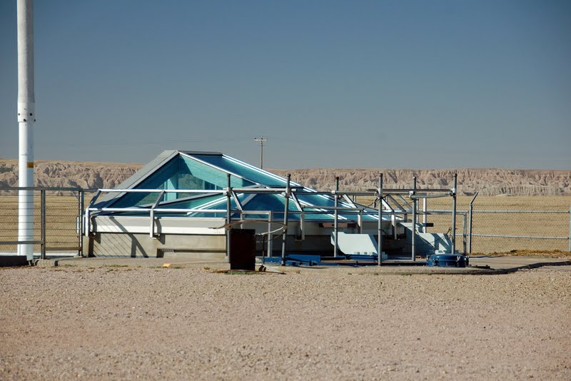
Eleven miles away is the second part of the tour, Launch Facility Delta-01, an actual missile silo. 

An inoperative Minuteman missile is in the silo. This site you tour on your own, with a cellphone tour available that will guide you around the silo...on the outside. We then finished up our tour at the Visitor Center, looking at exhibits, viewing the movie, and talking with the ranger on duty. It actually was very interesting and informative, and didn't cost a dime!

Another drive through the park as the shadows were lengthening....see us there??

Sunset heralded the time to head back to camp, and pack up for the long drive to North Dakota. 

I will definitely try to keep everyone updated on our beet adventures....our family is now calling us "beetniks" :-), but if you don't hear from us for awhile, rest assured, we are in the routine of work, eat, sleep and start over again!

Sunday, September 23, 2012

Memorials and Lakes

Our short visit to the Black Hills of South Dakota has been interesting, informative, beautiful, and tiring :-), We have spent every day since arriving visiting and taking in as many of the sights we can. I still haven't gotten into that delightful state of mind known as "taking it easy"....it may happen one day, but don't count on it :-).

This area is so steeped in history that it is hard to take it all in. I have picked up a couple of books to read, hopefully I will be able to get to them after our next three months of work are done. I know we went over all this history back in high school, but it doesn't really sink in what a travesty our country took part in with our dealings with the tribes of Native Americans..

We went to see the Crazy Horse Memorial here in Custer. This is the world's largest mountain carving, memorializing one of the Native Americans' most famous warriors and heroes. He was chosen not only for his skill in battle, but for his character and loyalty to his people. Henry Standing Bear explained the choice in 1939, saying "My fellow chiefs and I would like the white man to know that the red man has great heroes, also.”

This is the original sculpture by Sculptor Korczak Ziolkowski , and the mountain carving in the distance behind it.

This is the actual mountain carving as it looks today. It was officially started in 1948, and the face was completed and unveiled in 1998. The head alone is 87 feet 6 inches tall. The horse's head is the current focus of work, and will be 219 feet tall, or more than 22 stories high. the entire sculpture, when done, is expected to be 641 feet long by 563 feet high. Korczak depicted Crazy Horse with his left hand pointing in answer to the derisive question asked by a white man, “Where are your lands now?” Crazy Horse replied, “My lands are where my dead lie buried.” 

There is a whole complex developed at the site now, and a very interesting video is shown about the life and work of the sculpturer, Korczak Ziolkowski. There's many exhibits in the hall devoted to Native American life, The Native American Educational and Cultural center, as well as your normal souvenir shop and restaurant. No tax dollars are used whatsoever in this monument, it is solely supported by visitors and donations. 

Next up on the itinerary was a visit to Mount Rushmore National Monument.
The entrance to the Memorial is quite grand and patriotic, with the flags of every state and territory of the United States flying over the walkway. Sculptor Gutzon Borglum and 400 workers created the carving, working for 14 years before it was completed. 

We took the audio tour that is available, and enjoyed it very much. For $5.00 each we had the use of a handset and followed a trail throughout the park, making 29 stops to listen to videotaped discussion about the sculpture, the workers, the presidents, and the carving of the mountain. 

Washington and Jefferson up close

Roosevelt and Lincoln up close. It was so interesting to walk the Presidential Trail and listen to the tape. I would say it took us a good two hours to complete the tour, visit the exhibit halls and watch the movie presentation.

The original scale sculpture in the Sculpture's Studio. This is the model the workers use to carve the mountain of granite. We found it amazing how they could blast away the exact amount of rock needed to without destroying all the previous work. I mean, can you imagine getting almost to the end, and an errant blast wiping out Washington's face or something??

Now, to clear up any questions....there are no backsides carved into the mountain behind the figures :-). Underneath Lincoln, however, is the beginning of what was intended to be a Hall of Records containing documents relating to the Memorial. It was never completed, although the Borglum family continues to try and raise money for its completion. It is not open for public viewing.

While here in the Black Hills, we returned one morning to walk around Sylvan Lake. It is such a beautiful area, if we were working here this would be my favorite walk. The lake is beautiful from every angle.
The view from the start of the trail

The aspens are changing rapidly to gold now. It is beautiful, but I do miss the myriad of colors during leaf-peeping season in the Northeast.

The far end of the lake. The trail goes behind the rock walls, and below the dam that was put up in 1881 across Sunday Gulch.

The view from the other side of the lake. I could spend hours here! It was so quiet and peaceful. Unfortunately, I'm sure in peak season that plenty of other folks like to enjoy this area as well. I'm glad we were here in the off season :-).

For our last night here we decided to drive the Wildlife Loop one more time, as the sun was setting hoping we might see more animals moving around. We did find a large herd of buffalo, and for some reason they were stampeding down the side of the road and up over a hill. The pictures aren't so great as it was getting dark, but you get the idea.

A beautiful sunset ended our stay in the beautiful Black Hills!

Thursday, September 20, 2012

Custer State Park

I've heard many things about Custer State Park...the abundance of wildlife, the scenic beauty, that it's an "American safari"....basically, a not-to-be-missed park. I did enjoy it, very much, but sadly, the wildlife was a bit slim on this day, nowhere near a comparison to an African safari...and as many of you know, I've "been there and done that", so I can say that :-).

We woke to a bright sunny day, perfect for taking sparkling pictures. The plan was to drive the 67-mile loop in Custer State Park, comprising the Wildlife Loop, the Iron Mountain Highway and the Needles Highway. I had also downloaded several caches to try and find along the way. I can hear it now...."you plan on taking all day to drive 67 miles?"....yep, we were out for 9 hours all together!

The area that encompasses Custer State Park was originally designated as a game preserve in 1913. Then-governor Peter Norbeck's dream was to establish a large acreage within the Black Hills that would sustain the re-introduction of several species that had been driven away or close to extinction by the gold miners. Today, the park is home to a free-roaming herd of bison (buffalo) numbering approximately 1300, elk, big horn sheep, mountain goats and pronghorn. Mule deer and white-tail deer are prominent habitants as well, along with the prairie dogs!

 The Wildlife Loop is 18 miles long, and twists and turns through the rolling prairie and ponderosa pine forests. This big guy was our first wildlife sighting as we started down the loop.

The view east towards The Badlands from Heddy Draw Overlook.

We drove up the dirt road to the Mt. Coolige Firetower for a sweeping view in all directions..through binoculars you could see the Crazy Horse memorial, the Needles (above), Mount Rushmore, Harney Peak and The Badlands.

This is a lonely grave on the prairie we found while geocaching. "Dr. Alvin Herbert settled along the South Fork of Lame Johnny Creek in 1888 near the stage station so he could get his medications directly from the coaches. A well respected citizen he was at one time the postmaster of Bakerville, born in Ohio on October 28, 1824 living in seven different states before moving here after the death of his wife. One of his sons Almon ran a large ranch in the area and upon his death the Dr was buried on Almon’s ranch. A concrete marker set with various native stones was erected over his grave. Today it is the only visible manifestation of the Bakerville area."

I thought the marker was beautiful with all the native stones set into it.

Not quite-so-wild wildlife along the way...the burros live in the park, having been released in the early 1900's from the tourist trade, carrying folks up and down Harney Peak. As you can see they are quite friendly.

The buffalo herd was not very close to the loop today. There was a path leading out there, and many folks were waltzing happily down it, but I was paying strict attention to the "buffalo are dangerous do not approach" signs. It led through a prairie dog town as well, and knowing the fleas from them carry disease, did not want to approach them to closely either. My last reason is I know that the prairie rattler often hangs around prairie dog towns, and being that I haven't seen one the entire time I've been out west, I would like to keep it that way, thank you!

The closest pronghorn I came across. I had always thought they were antelope, and are commonly referred to as antelope, but they aren't. Antelope are found exclusively in Africa. They are simply pronghorn. They are often cited as the second fastest animal on earth, after the cheetah. That must be why I've had a hard time getting a good picture :-).

As we exited the Wildlife Loop, we stopped at one of the very nice General Stores in the park, the Coolidge General Store, for some sandwiches and drinks and had a nice picnic lunch on the grounds. Being here in the off season is very nice, crowd-wise :-). We then started up the Iron Mountain Road, and came to our first view of Mount Rushmore where the faces were discernible. (you can click on any picture to make it bigger and see it better)
"The Iron Mountain Road is a work of art in itself. The highway connects Custer State Park and Mount Rushmore National Memorial. The highway passes through some of the most beautiful scenery in the Black Hills and including three tunnels that frame Mount Rushmore in the distance. The road is famous for the "Pigtail Bridges" that allows travelers to drop or gain altitude quickly.

The highway was constructed in the 1930s under the direction of Governor Peter Norbeck, who is also known as the "Father of Custer State Park." Norbeck said of the Iron Mountain Road, "this is not meant to be a super highway, to do the scenery justice you should drive no more than 20 mph and to do it full justice you should simply get out and walk." Experience the road that engineers once said couldn't be built; you'll be happy you did."

Each of the three tunnels have a view of Mount Rushmore as you are going through them, south to north.

Geocaching along the way! Casey is helping on this one, Chelsea decided she didn't want to get out of the truck for this one. We had just finished a two-mile hike on the Iron Creek Trail, and she was tired :-). There are trailheads all over the area for your hiking pleasure.

An ever-closer view of Mount Rushmore. As we exited the Iron Mountain Highway, this is the closest we would get to the Memorial today. Visiting the Memorial is on tomorrow's agenda. A quick stop in Keystone for some ice cream and a restroom break, and we were on to our third leg of the day, the Needles highway.

First was a stop at Sylvan Lake. This is a beautiful recreation area, with a few hiking trails and boating rentals. It was getting late in the day, so we didn't walk around the lake, but it is on the agenda for our last day here.

"The Needles Highway is a spectacular drive through pine and spruce forests, meadows surrounded by birch and aspen and rugged granite mountains
The road's name comes from the needle-like granite formations which seem to pierce the horizon along the highway.
The roadway was carefully planned by former South Dakota Governor Peter Norbeck, who marked the entire course on foot and by horseback. Construction was completed in 1922.
Visitors traveling the highway pass Sylvan Lake and a unique rock formation called the Needle's Eye, so named for the opening created by wind, rain, freezing and thawing."

The formations are awesome along here!

We approached the smallest tunnel on the highway....12 feet high and 8feet 4inches wide...we'll have 2 inches to spare on either side of our hips!

Before heading to the tunnel though, this formation is "The Eye of the Needle"...really cool.

Al had me walk through the tunnel to get a picture of the truck as it came through the tunnel...not much room to spare, but we made it! Cheers and applause as we went through, too funny!

The formation known as Cathedral Spires. 

One last view along the Needles Highway as we headed back to the campground.

The drive was beautiful, and different in so many ways. The three sections really highlight the beauty of the Black Hills. It was a long day, but so worthwhile. The next section will be our visits to the two big memorials in the area, Crazy Horse Memorial and Mount Rushmore National Memorial. Thanks for sticking with me, and also for all the wonderful comments, they make my day!