Welcome to our Adventure!

Al and I are thrilled that you have found your way to our blog. We hope you enjoy reading our journal and viewing our photographs of the natural wonder of our United States of America. Let's hit the road together!
Homer, Alaska

Saturday, September 8, 2012

Hike to Mohawk Lake

Well, the temps are starting to cool out here in the mountains, usually the temperature is in the 40's when I get up to take Chelsea out...no more flip flops in the early A.M.! And its starting to feel and look like fall. The aspens are starting to turn in the higher elevations, and its really neat to see patches of gold among the green. The air is crisping up, and that's the signal that moving time is approaching.

Tuesday we had gone up to Breckenridge to spend the afternoon with Mark and Keira. They had gone horseback riding in the morning near Fairplay, and wanted to go on a hike after lunch. The lodge they were staying at recommended a hike to Mohawk Lake, so we decided that sounded like a good one.

We left Chalk Creek a bit earlier than necessary so we could get a little caching done along the way :-).

There are so many forest service roads that go off the main highway, we just picked one and drove down it, marveling at the scenery and looking for caches.  

There's a cache here at this gnarled old bristlecone pine, called the Millennia Tree. There are rumors that its the oldest living tree in Colorado, over 1000 years old.

Chelsea is exceptionally perky today, a good thing considering the hike we have ahead of us!

Starting up the trail to Mohawk Lake. In reading the description of the hike, there are two different trailheads. The first one is at the end of the "improved road" and the hike would be just over 7 miles from that point, with an elevation gain of 1,750 feet. That sounded a bit intense to me, plus the fact that we weren't getting out on the trail until after 2PM. So we piled into the truck at that point, and followed the "high clearance vehicle" road to the second trailhead, which would be a 3 mile roundtrip hike, although still with a pretty good elevation gain of almost 1,000 feet. We were skipping the easy part!

The first section of the trail went through a beautiful smelling pine forest...love the smell of pine trees!

As we emerged from the forest, we could see Continental Falls....it looks a lot closer here than it really was, but we are heading for the top of the falls where Lower Mohawk Lake is.

There are several collapsed log cabins left over from the late 1800's mining era

Crossing a creek....

the trail starts to get more open and rocky

We got closer to part of the falls. It was a whole series of cascading sections going down the mountainside. I can only imagine how beautiful it is in years of high snowfall.

Chelsea is being a real trooper for an old lady! Of course Casey could have run up and down that trail 5 times!

A final view of the falls cascading over a ledge and we were ready for the big push to Lower Mohawk Lake...1/2 mile and 500 foot elevation change!

Switchbacks on a rocky trail...we're starting to get above treeline at this point

Skinny trails

The remains of an old wooden tower that was once a part of a tramway for lowering ore to a mill far below.

Oh look! There's a geocache to be found and recorded :-). I think we may have made converts to the hunt!
What a view, huh?

The final push....we see the beginnings of the waterfall....Keira promised me that meant the lake was near!

The trail flattened out, and as we made our way through some thick brush, I could hear the dogs barking up ahead...that could only mean one thing...they were in the water!

We had finally reached Lower Mohawk Lake, and it was a stunning beauty of an sub-alpine lake...at 11,800 feet, surrounded by the light vegetation that grows just at the treeline, boulders rimming the lake, surrounded by mountain peaks. 

The east end of the lake as it heads toward the waterfalls

Mark was inspecting the water for signs of trout

The creek running down for Upper Mohawk Lake that fills Lower Mohawk Lake

Lower Mohawk Lake is very shallow, you could walk across it and probably never get deeper than your calves.

After soaking in the views for awhile, it was time to start heading back. Sometimes I think going down is almost as hard as going up!

Al and the pups pulled ahead of us by quite a wide margin...I think Chelsea was anxious to get back to the truck and go to sleep!

Back through the forest, and back to the truck. It was one of the most vigorous hikes we've done, and I feel quite proud of myself for getting it accomplished! Once back in town we had a nice dinner at The Whale's Tale, and headed back home to Chalk Creek. 

Wednesday was Staff Appreciation Day here, and Lars and Tamara had planned a special day for us all. We had such a good time! First we had our normal staff meeting, where we plotted our course of action for dealing with the couple hundred high school bike racers that are descending upon us today...should be interesting :-). Then they sent us on a scavenger hunt, where we had to gather clues to co-ordinates for our next destination. That turned out to be a mini-golf course in Salida, where we had a rousing competition between two teams to claim the victor's prize...a decorative golf ball! Joe won the competition, and decided he was going to make his international flag golf ball into a geo-cache..sounds cool to me! We then had a puzzle we had to put together to get co-ordinates for our last destination, which turned out to be the Boathouse Restaurant in Salida, where we all had a long leisurely lunch. It was a great day, and we feel so privileged to have worked at such a fine campground with so many great folks. It will be very hard to leave them next week!

A few folks have asked which GPS we are using for our geo-caching. Well, we are actually using the geocaching app for our Iphone...it cost $10.00 and has worked great for us! And if there are folks out there that also geocache, our name is "moseycat", and we'd love to be your friend :-)!

Well, time to get ready for work today, so for now, this is THE END until the next adventure, coming soon!

Thursday, September 6, 2012

Jeeping Up Tincup Pass

The past few days we have been very busy. We not only had Labor Day Weekend to contend with, but we had visitors from back in New York come out and spend a few days with us. It sure was nice to see some old familiar faces :-). Friday and Saturday we were busy working at the campground, but had Sunday off. We had been trying to decide what to show Mark and Keira, to give them a flavor of life up here in the mountains. We finally decided on renting a jeep, and taking them jeeping up to St. Elmo, over Tincup Pass to Taylor Lake reservoir, and back over Cottonwood Pass to Buena Vista. They were game, and off we went. We left pretty early in the morning, for us, to avoid the late afternoon showers.
First stop was St. Elmo's ghost town

We also introduced them to the favorite summer past time here, feeding the chipmunks!

They are not shy! I had two of them actually in my hood, squabbling over some seeds. Too funny!

Keira even overcame some initial qualms and had them eating out of her hand.

Tin Cup pass was originally used to move supplies between the St. Elmo and the town of Tin Cup. It was established in the 1870's. When trains came to the mining towns, none came to Tin Cup. There was a train that came to St. Elmo. There was a need to get ore, people and supplies between both cities and Tin Cup pass was used every day of the year during the early part of the 1880's for that purpose. The section from St. Elmo to the top the the pass is pretty torn up, and requires a vehicle that can handle rocks and roads that have large pot holes in them. This is a relatively easy section of the pass. The kidney rattling section was to come on the way down!

At the summit...the highest they've ever been!

We even had our picture taken...something we don't have done very often :-)!

Mirror Lake on the downside...too windy for reflections, and the clouds were starting to roll in.

I love the signs in these old remote towns.

 
A beautiful hawk was flying overhead for awhile, but never got close enough so I could identify it.

We stopped and had our picnic lunch near the dam at the end of Taylor Lake Reservoir, and then piled back in the jeep for the return trip via Cottonwood Pass. It was starting to spit rain at this point, and was getting windy and cold, especially at the top of the pass...I think it was in the 40's up there! We were keeping our eyes peeled for elk or moose, but did not see any signs...bummer. 

Back in Buena Vista, we took a short walk along the Arkansas Riverfront, and watched folks setting up for a music festival in the park. After returning the jeep, we headed back to the campground for the holiday running of the rubber duckie races. Thankfully, the rain showers were over by that time, and we had a very successful race, with over 70 duckies participating between the adult and children's races. We raised $153.00 for the Ark Valley Humane Shelter. We then headed down to a local favorite restaurant, Coyote Cantina, for a great Mexican dinner that all of us rolling out with very full tummies. We called it a day, and headed back to our respective beds, with plans to get together Tuesday for a hike to Mohawk Lake near Breckenridge. And that story and pictures will be in my next blog entry, so stay tuned!

Tuesday, September 4, 2012

Bishop's Castle and Geocaching Fun

Last week was mostly laid back, staying close to the area and doing some cleaning on the trailer in preparation for our move on the 12th. We did take a day trip to see one of Colorado's quirkier attractions,
Bishop's Castle. For forty years, Jim Bishop has been building a castle on a mountainside in Wetmore, Colorado. We figured it was something interesting to go see, and was a beautiful drive through ranch country  near Westcliffe, a scenic area east of the Sangre de Cristo mountain range. A scenic byway, Frontier Pathways, also runs through the area.

We arrived first at our furthest point of the day, Bishop's Castle.
As the sign says, it has been built by hand, using more than 1,000 tons of rock hauled to the building site by Jim Bishop from the nearby San Isabel National Forest.

This was the sign that greeted us as we walked up the driveway!

Another sign. I have to warn you, Jim Smith has very definite views of the government, and politicians...he doesn't like any of them! Can't say as I blame him nowadays....:-).

Walking up to the entrance


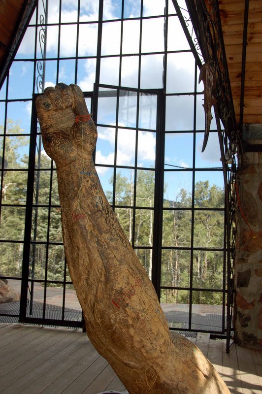
Inside the castle...an interesting mix of ironwork, stained glass and sculpture. Casey and Chelsea didn't care for walking on the open metal grates on the stairs, so they went back down

They're way down there by the "gift shop"

I went outside on the "balcony" and took this picture of the tower...you can go up there, but can't say as I was too comfortable on those open walkways either! You can go up into the top of the tower and ring the bell, but I admit I was feeling a bit of vertigo and decided to come back down myself

The outside stairs!

The castle as seem from a trail across the street. It was definitely an interesting "off the beaten path" site to investigate.

We turned around on the ByWay at this point, and slowly headed back towards Chalk Creek, geocaching along the way. We stopped at this neat little spot for one, down a dirt road in the San Isabel National Forest
The Mingus Family Homestead, an early 20th century ranch that has been renovated by the Forest Service, the Frontier Pathways Scenic ByWay, and the Colorado State Historical Society. 


Ranch land scenery near Silver Cliff with the Sange de Cristo mountains in the background. It was in the town of Silver Cliff that we made one of those discoveries we so treasure being on the road. We were really hungry, and stopped at the first place we saw that had food...let me tell you, few and far between :-). It turned out to be a pizza and Italian food restaurant, with THE best pizza and sausage hero we've had since leaving New York. It was a riot. The owner stopped by our table to talk with us, and turns out she is from New York...I knew it as soon as I heard her say "forgetaboutit"! The restaurant is for sale, long story short, she wants to "get back to Boca" :-). But I am still licking my lips over that pizza!

A few more caches and we were back in Westcliffe, with one of them at the "All Aboard Westcliffe Interpretive Center"

Trains are a very big part of Colorado history, and the town of Westcliffe was actually founded by the Denver and Rio Grande railroad to service the silver and gold mining camps of the Wet Mountain Valley.

It was an interesting and beautiful drive in an area we hadn't explored, well worth spending a day on! And we collected 14 geocaches that day as well! Later in the week, the geocachers all got together on a morning we had off, and went out caching together on the Narrow Gauge Trail, our favorite hiking trail in Chalk Creek canyon.
It was a beautiful morning, and 5 people and 4 dogs set out for some fun and exercise...this is Al, Joe, Tamara hiding in the back, and Sandi with Osaka and Kyoto. Casey and Chelsea are up front with me!

Found one! See the big thumbs up?

I'm very proud of Chelsea with the little dogs...she really behaved herself! 

Is this not the most beautiful morning on a most beautiful trail? I never get tired of it!

Geocaching is serious business! Must check those co-ordinates!

Pups all patiently wait for the silly humans to find whatever it is they're looking for.

One of the caches were hidden very well...some rock-climbing was needed to get to this one!

We finally reached what Chelsea was looking for...the creek! Time to get a drink and cool off.

Chalk Lake and the Chalk Cliffs of Mount Princeton...another site I never tire of...our summer backyard this year!

Alas, it's time to head back and get to work...so for today, here's 
The End!