
First we drive through the Valles Caldera National Preserve. This fifteen mile diameter caldera is over one million years old and is the centerpiece of the Jemez Mountains volcanic field. The caldera was formed when the volcanic pile collapsed due to a huge eruption in the magma chamber. Subsequent eruptions formed domes along the caldera ring fracture including Rendondo Peak which rises 3000 feet above the caldera floor. It actually reminded me a bit of the Ngorongoro Crater in Tanzania Africa, which we visited while on safari in 2008.

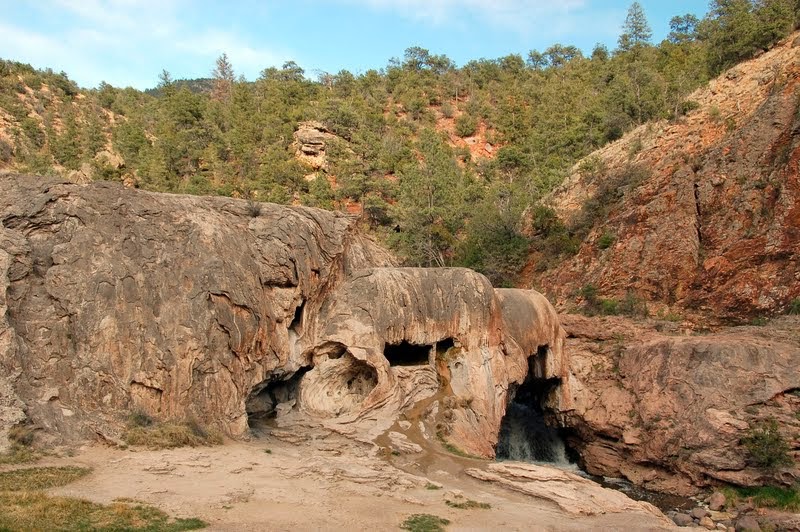
Thinking we had missed the turnoff for the Jemez Waterfall trailhead, we stopped at a different trailhead and took a walk in the forest. As we left there we did see the other trail, so we stopped there as well and took a walk to see the Jemez Waterfalls. I had had my doubts that there was actually any water around, but we did see some falls!

Al Casey and Honey went down for a closer look.

It was really starting to get a bit late at this point and we still had about an hour and a half drive back to the campground, so just a few quick photos stops took place after that. This is Battleship Rock, named so because it looks like a massive prow of a battleship jutting from the cliff behind it. There's a very nice park and picnic area here at the base.
Soda Dam is a unique formation of colorful "petrified" water shaped like a domed falls, where the Jemez River bubbles into the hot springs rising along a deep fault.

Who can resist a shot of the red rocks with the sun going down?
Since it had gotten so late, and the planned dinner needed to be baked in the oven for awhile, we decided it was a good night to check out a local restaurant. For everyone out there that watches "Diners, Drive-ins and Dives", did you know there's an "app for that" (it tells you if there's anyplace that Guy Fieri has profiled nearby). I checked it and found Back Road Pizza only 2 miles from the campground. Off we went, and it was really good! As the saying goes, "winner winner chicken dinner", or in this case, pizza and garlic knots :-0!
We spent our last day in the Santa Fe area visiting Petroglyph National Monument.. This site is home to one of the largest collections of petroglyphs in the country. Petroglyphs are designs and symbols carved onto volcanic rocks, in this instance by Native Americans and Spanish Settlers 400 to 700 years ago. The 17-mile long escarpment was placed on the National Register of Historic Places in 1986, and was established as Petroglyph National Monument in 1990 by Congress.
There are four separate day use areas in the park, each of which has hiking trails. Boca Negra is a paved, ADA accessible trail with a good selection of petroglyphs. It is however, not dog friendly, so that one was unavailable to us. The 2.2 mile trail at Rinconada Canyon is temporarily closed due to trail collapse and unsafe conditions (after doing a hike a week later in Canyons of the Ancients, I shudder to think of how bad the trail must be for them to close it!). So we headed off to the 1.5 mile Piedras Marcadas Canyon trail, about 6 miles from the Visitor Center. It is a bit unsettling to realize that the park is set in the middle of an immense residential area, but once you set out on the trail, all is peaceful and quiet.

The landscape as we headed up the trail

Getting closer to the escarpment of basalt boulders formed from lava and volcanic eruptions. Over time, softer sediments on the mesa's eastern edge eroded, leaving behind this jagged-edged escarpment. This is the natural setting for the petroglyphs we are seeing.

Long ago people discovered that chipping away the rocks' thin desert varnish revealed a lighter gray beneath and left a lasting mark. Native Americans believe these images are as old as time. Archeologists estimate most images were made 400 to 700 years ago by the ancestors of today's Native people. Some images may be 2,000 to 3,000 years old!

It seemed as if every turn brought different and fascinating images into view.

I enlarged this one so you could see the example of human like faces looking out from two sides of a boulder. Scientists ponder why these images were created, and what do they mean? It would have taken a long time to create these images, so subject and setting for each petroglyph were carefully planned.
Of course, my husband, ever the realist, thinks it would be highly amusing if it ever came to light that the carvers were simply drunk and amusing themselves, or if ancient mothers sent their kids out to "draw" and get them out of the way!
There is a fourth section of the park, Volcanoes, which also has a dog-friendly trail. We opted not to explore this one as well, as we had gotten a bit turned around and walked a good bit further than we needed to! It was also incredibly windy, with the dry desert dirt swirling around all of us. I was glad I had worn my sweatshirt, as I used it to protect my camera from the flying dirt, but we all ended the walk feeling as if we had eaten mouthfuls of dirt and wasn't up for any more!
This brought to an end our visit to the Santa Fe area. We really didn't explore the city too much this time, but we did get to ring up three more National Park sites in our passport book, and learn quite a bit about the early Ancestral Puebloan people. On Thursday morning we packed things up and got back on the road again, bound for the "Four Corners" area of the country and staying in Cortez, Colorado. We left Santa Fe on I25 south for several miles, then picked up US550 going northwest. This route took us through some absolutely breath-taking scenery. It wasn't a great day for traveling however, as we were alternately sprinkled, sleeted, hailed and snowed on! It was all light precipitation, however, and did not make traveling difficult at all. Once arriving in the town of Aztec, we turned due north to Durango, Colorado. From there it was an easy ride to Cortez on US160, where we got settled into the Cortez/Mesa Verde KOA. We had a fantastic view of Mesa Verde from our site, and I am looking out my window at it as I write :-). And for those of you curious about our route, it has been entirely big rig friendly, easy to drive, good refueling stations, and I can't believe we've gotten all the way out here and UP here without dealing with any nasty mountain passes! We are also extremely happy with the decision to have me drive the SUV behind, as it is much less wearing on the truck now (we don't use it for short jaunts and local travel) and the SUV is SO much easier to navigate towns, parking and sightseeing with. So that is working out well.
As soon as I have our pictures ready from our explorations here in Cortez done, I'll be posting all about that. Tomorrow we are moving again, and heading to Thousand Lakes Campground in Torrey Utah for a week of exploring the Capitol Reef National Park area. We'll see if there's snow there!
Glad you are enjoying New Mexico. Thanks for the info on the Triple D app. I am all over that. It is too bad Bandelier is not dog friendly. We had to leave Grace in the car and when we got back she was hidden under the front seat. Catherine was in full panic-thinking she was stolen.
ReplyDelete