Vicki, the dogs are doing great. The have really adjusted to this life quite quickly, and we are grateful for that. As you know, we started getting them accustomed to being in the trailer by themselves at the rally. We just make sure that there is a routine, and they are used to it and what it means. We always pull the shades down, turn the fan on and leave the tv going as a buffer for any outside noise. They get a walk before we leave, then treats, told to get on their couch and be good, we'll be back soon. And for the most part, they just nap while we're away! Al and I are not on the same time schedules either, there is some overlap some days, but really, the longest they go alone is around four hours. When my hours get longer after Memorial Day, I can walk back during breaks and let them out for a few minutes. And Al is always driving by in his cart, and able to check on them as well. So it really is working far better than I had imagined.
Sherry, scooping ice cream is an art :-). You want to make sure the level of ice cream goes down evenly, so as to not have ice cream climbing up the sides of the container; that can lead to grainy or gummy ice cream. You imagine the container as being divided into quarters. Put your scoop in about a half inch deep, at the 3 o'clock position, along the side, and scoop up towards 12 o'clock, then straight dow to the middle, and across back to 3 o'clock. This is supposed to give you a nice, 4 oz. scoop of ice cream. Plop it down on top of the cone, with an overhang (giving the illusion of extreme generosity with your scoop!), and there's your single scoop ice cream cone. Repeat with the other 3 quarters of the container, and then start your next layer down. Sounds easy, we'll see how co-ordinated I can become :-).

The entrance to the Park Store. It's supposed to be slated for painting, we'll see if they get to it before we get busy!

Racks of canoes and rowboats available for rentals by the lake.

One of the jumping in spots for the dogs.

Chelsea's little "frog pond"; there's several frogs living in this pool, and she has to check it each time we walk past.
Tuesday the sun was actually out when we got up! It was short-lived, but at least we saw it :-). It wasn't as cold, either, and I was ready to get out of the campground for awhile. I had shopping to do, the fridge was getting a tad empty, and so I looked through my papers for a nice walking spot close by. I settled on Proud Lake Recreation Area, about 13 miles from here. It covers 4700 acres, and has over 20 miles of hiking and biking paths. It's situated along the Huron River, with Proud Lake at the eastern end. There's great fishing (yes, Al does have his Michigan fishing license now and will be heading up there with his rod!), a group primitive campground, and a modern campground with 130 electric RV sites.

We decided to do the Marsh Trail, onto part of the red trail leading to the dam, then followed the Chief Pontiac Trail to the River Trail back to the parking area. It wasn't a long hike, but it takes us awhile, as we like to take our time and look at everything :-).


Michigan State Parks have a very nice trail marking system. You can pick up a numbered trail guide at the park office that co-ordinates with these markers. Each marker has a trail guide posted, and numbered arrows showing you which direction to take, especially helpful when there's a crossing of multiple trails! So you're able to mix and match trails according to how far and where you want to go. It's really nicely laid out. Seven Lakes had this system, but Highland Recreation didn't, at least not yet.

This little bird landed long enough for a picture, anyone able to help identify him? We also saw our first Scarlet Tanager, but he was way too fast for me to get a picture!

It's one mile around the marsh itself, and there's a nice system of boardwalks in place over the mushy areas. Or at least, there are on this trail...more on that later :-).

I saw lots of red-winged blackbirds here; I was hoping to see some of the herons and other marsh wading birds, but no luck. Al said they were hiding somewhere, shivering :-).

The wooded area on the far side of the marsh. This is where we saw the tanager, and also heard woodpeckers. The only one I caught a glimpse of was a red-bellied woodpecker. I'm still looking for that pileated dude!

This swan came gliding over to check us out as we were scanning the shoreline. There was a female sitting on a nest in a small island in the marsh, I guess this guy was making sue we didn't have any ideas of bothering her.

This is the portion of he Huron River descending out of Mossy Lake, a smaller lake spilling from Proud Lake. Right behind us is a dam, funneling the water into the main Huron River. This is where we saw some really large fish as we walked up, hovering right at the top of the dam.

Here you can see the dam, and how fast the water is churning as it goes over it, being funneled down river. The fish were hanging out right on the left side of the dam, I tried to get pictures but they didn't come out very well. We picked up the Chief Pontiac Trail on the far side of the bridge, down past that little outhouse.
Chief Pontiac was apparently an important figure in history along here. There were several markers posted along the trail, noting a feature of the area, such as a particular tree or feature, and then noted it's place in the Ottawa Indian lore, and then a note about how Chief Pontiac used it. It became quite clear that Chief Pontiac disliked the British very much, as most of the notes pertained to how he would utilize each feature in his rebellion against the British Invaders. When we approached the sign for the Oak trees, Al was surprised when it said nothing about the rebellion; he expected to hear how Chief Pontiac instructed his warriors to make bats out of the oak to beat the British soldiers with! There is a city of Pontiac nearby, as well as Pontiac Lake Recreation Area and yes, the GM vehicle was named after the chief :-).

The dogs never refuse a dip in an accomodating river!

There's a lodge in this park that you can make reservations for, and this campfire circle on the riverside is just a short walk below the lodge.


Some wildflowers along the boardwalk. I couldn't get the angle I wanted on these spiky flowers, so after checking the area for any dangers, I laid on my side for this shot at plant level. I was happy with it, until a few feet further up the trail, after the boardwalk ended, we found this fellow:

Yes, I know, it's only a garter snake, but it's a snake! Yechh!
I cautiously made my way past, and we continued down. The trails were getting mushier, and water was starting to cover portions of the boardwalks. We splashed our way through some, jumping over deeper spots, until we came to s section of no boardwalk, and at least knee deep water; at least, it was up to Casey's belly! So we turned around, and headed back to the last intersection, and yes, I had to go past my buddy again! It was ok, though, because by going that way, we got to walk on this trail, with the tallest red pine trees I've seen so far!

We returned to the parking area, and got out our sandwiches and sodas for lunch. It was almost warm enough, so we ate outside at the picnic tables they have there. There's also grills, if a family wanted to come barbeque after walking the trails. There is a parking area closer to the dam for fishermen, and picnic area there as well, so I'm quite sure that will be an excursion for another day.
Before leaving the park, we drove over to the boat launch area, and checked out the campground. I took some pictures for folks who may be coming near the area. It looked very nice, and definitely quiet right now! There was only one motorhome in the whole place. They also have two cabins they rent. There's canoe rentals, and lots of activities for the kids..basketball courts, horseshoes, a playground, volleyball nets.


Check out the giant fire rings they have here!
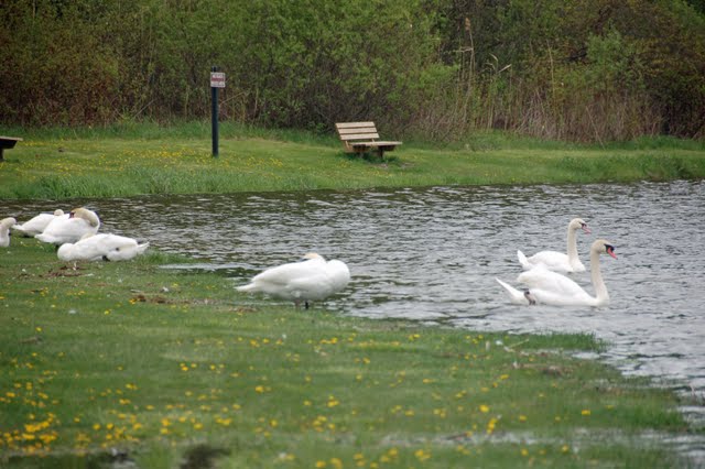
Lots of swans were congregated down by the boat launch. This boat launch was specifically for the campground, and there's a public one further up the road.

These birds were swooping all over the lake, and one finally landed long enough for me to take a picture. They are tree swallows, and until he stopped moving, I had no idea that they were blue! They are really fast, and not afraid to dive-bomb you :-).
That ended our day at Proud Lake. We returned to Hartland, did our shopping, I had my ice order arrive just as I was returning to Waldenwoods, so I went up and took care of that. Al rangered last night, and the rain returned. This morning is still drizzly, but warmer, and I'm watching the birds out here. There's at least 2 sparrow nests in the pine tree, and a pair of robins are building one also. The goldfinches are eating dandylions! I had bought a couple of plastic planters and flowers, I'll get those planted today, and we have two hanging baskets of red/purple flowers and a hanging hummingbird feeder. And yes, the hummies have found their way here already, I'm just waiting to get a picture for you.
That's it for now. Al has two nights off, and then starts again, and I start up the store on Friday for the weekend. I have orders coming in that need to be marked and put away, and the forecast is nice and warm for Friday and Saturday, so hopefully, a busy weekend is on tap. Until next time, have a great day!
Looks like a good place for the four footed members of the team. If we get that far north this summer, we will have to check it out.
ReplyDeleteWhat a nice day trip and a great place for a hike. I bet the dogs loved it.
ReplyDeleteNice looking hiking trail. Boy, your sky looks about the same color as ours has been for weeks. Dull grey! Can't remember what a clear blue sky looks like!
ReplyDeletewww.travelwithkevinandruth.com
Great hike!
ReplyDeleteThat was a great post. Thank you. Do you remember us from the rally? Jayco designer across the road from you with Tatum. Wish we were as far along with our road to full timing as you. But I know we will get there! Take care, Neil & Nancy
ReplyDelete