River Plantation is a nice campground, right off Parkway in Sevierville. Parkway runs from I40 through Sevierville and Pigeon Forge to the north entrance of the Smoky Mountain National Park. As one of the rally attendees stated, Pigeon Forge is "like Myrtle Beach on steroids"! I was dumb-founded as we drove through Pigeon Forge, and will take some video next time and try to post it here on the blog....and the folks back home think 7-11 moving into town will ruin everything! :-).
We arrived around 4PM, and quickly set up. The sites are wide, paved, mostly level, and there's a little shade tree! Our hosts, Linda and Howard Payne of RV-Dreams, were on hand to welcome us, and invite us down to their site after 5Pm for "the circle". This is a tradition that has started at rallies, "happy hour" at Linda and Howard's site, everyone brings their chairs down, sets up a circle, and conversation abounds. It's really neat, and even as strangers, we were welcomed by everyone.
The rally does not officially begin until Tuesday, when registration takes place, and there's a welcome dinner and ice-breaker gathering. Classes start Wednesday. So Monday was a free day, we we took advantage of the weather being sunny to engage in some outdoor activity.
Before we had left Sag Harbor, a friend of Al's had given him fly-fishing equipment to take with him, as this will be the predominantly form of fishing he'll be engaged in from now on (except of course on visits back to Long Island where I'm sure there will plenty of salt water fishing on the agenda :-)). We discovered one of the rally attendees, Mike, is a guide from Maine, and was offering fly-fishing instruction for anyone who would like to join in. So that is what Al was doing Monday morning...learning about casting! It was such a nice thing to do, as I know it is quite expensive to take fly-fishing lessons. In the meantime, I spent the morning working on finances, getting the checkbook updated, paying bills, and updating the budget spreadsheets. I also got a dinner list for the next week set, and a grocery list set for Tuesday shopping...hey! what's wrong with this picture? :-).
After he returned, we decided to head out and try to do a driving tour before bad weather set in...there were thunderstorms forecast for late afternoon and all night. After going to the post office to mail out a couple of packages, and CVS to renew some prescriptions, we headed to the Smoky Mountains. Our destination was the Cherokee Orchard Road and Roaring Fork Motor Nature Trail. This driving tour was the closest one, and being that we weren't sure how long the weather would hold, it seemed the smartest choice. We would also like to do Cades Cove, but it's much longer and says to plan about 4 hours total to do the trip. We're planning on doing that on Friday, our next free day.
We stopped at the Gatlinburg Welcome Center, and picked up Smoky Starter Kit for maps and general guides, and also Smokies Road Guide; I think we're set! We then drove to the Motor nature trail, and started heading up, Initially, it's a two way road, but once you start the motor trail, it's a 6 mile, one way, windy twisty loop road. No buses, motorhomes or trailers allowed, and I can see why! At times, I wasn't sure our big old pick-up was going to twist around without hitting something!
This was one of the wider sections of roadway :-).
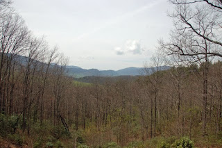
Roaring Fork is the mountain stream that courses down Mt. Le Conte, and was also the name of a farming community up here that was settled in the 1830's to 1840's. About 2 dozen families eked out a living up here, but it was very harsh, and the land not real hospitable to farming. This is a view from the highest point of the motor trail. You can see the mountain peaks and ridges rolling across the distance, but over the last 50 year, air pollution has created a haze that makes seeing long distances impossible any more.
This is the trailhead for Trillium Gap Trail, that leads up another 3400 feet elevation change to the crest of Mt. Le Conte, and to Grotto Falls. We had thought to hike the 1.5 mile trail to the falls, but there was this terrible sign at the trailhead that said "no dogs". Bummer!
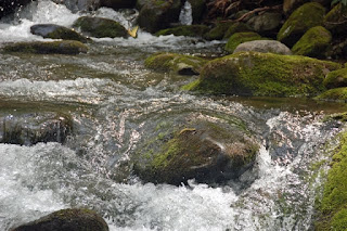
We then continued down the road, and stopped at this cute little waterfall. The dogs were able to jump out at this point, and as it was a warm afternoon, they figured it was a good spot to splash around and get a drink!
Refreshing cold stream water!
These are preserved buildings at the Jim Bale's homestead. I love these types of fencing, I think they are so picturesque!
Dogwood trees are in bloom down here.
If you look close, you can see one of them to the right of the center top of the photo; also, if you didn't know, if you click on any photo in the blog, it will make the photo bigger for viewing detail if you like!
That was the end of our driving tour for the day, and we headed back to the campground for "the circle" time, put together some dinner, and then we were invited down a few sites for a campfire, which we accepted. We decided to leave the pups in the trailer for awhile, it's time to get them used to being alone. And they did quite well, until the thunderstorm started rolling in. We had a pretty good storm roll over us, between 11 and 12PM, and Chelsea ended up sleeping behind the recliner for the night. Hopefully, that's the last storm for awhile!
Today it rained all day; so it was pretty much errands in the morning, some phone calls, (if anyone is keeping track, we finally have a closing date for the business sale, April 29, YAY!!!) and registration in the afternoon. Again, the pups were in the trailer for a couple hours, and again tonight when we went to dinner. We pulled the shades, left the TV on ( Food Network, if anyone wants to know what the pups are watching), and they did great! We're so happy about that.
Tomorrow our classes start, and more people to meet. There's a chili cook-off for dinner tomorrow, and we expect to have another interesting day, full of information and interesting people. No pictures,probably, until Friday's drive, so stay tuned!


Beautiful tour and love all the pictures. Congrats on your closing...
ReplyDeleteWe really enjoyed River Plantation RV park and the whole area. Nice pictures of the countryside.
ReplyDelete