June 11- June 18
Fort St. John, BC, to Tok, Alaska
Upon repairs being completed, we left Fort St. John and headed north to rendezvous with our traveling companions who had continued on
slowly. We moved a bit more quickly through the Alaska Highway than we had
planned, but we will get back on schedule for the prime attractions and
reservations in Alaska. Once again, we are so grateful for the hard work of the
repair shop workers to get us back on our trip.
Day One: Fort St. John to Fort Nelson: Straightforward simple driving day. 240 miles, which is on the longer side for this particular trip and highway. But the roads were fine except for one short section at the bottom of Pink Mountain where there were some bumps that you need caution with. We were hypervigilant to any noises coming from the back, but all was fine. Everything was still where it was supposed to be. Yay!
Day Two: Fort Nelson to Muncho Lake: The highway is getting
dicier as we are now progressing through the Canadian Rockies for the next 200
miles. We had a shorter drive planned as there is construction going on in this
section. A few grades up 6-9 percent and winding roads made concentrating on
the highway a must. We stopped for the night at Muncho Lake, a stunningly
beautiful lake known for its deep green and blue waters. We were definitely in
a remote area with no cell service. The lodge/campground advertised a Wi-Fi
hotspot, but it wasn’t worth diddly-squat. I was also not happy with the site
we were initially given – it involved backing down the road and trying to back
in the site between several trees. If the lake had not been much higher than
normal due to flooding up here, like in the States, we could have done it. As
it involved making a swing that would have submerged the truck into the lake,
we declined to take this site and asked for somewhere else. Thankfully, we were
accommodated with a different site and given a discount as compensation. Diesel
fuel here was $2.56/liter, but we did get a 20-cent/liter discount for staying
there. But it has been the highest we’ve paid so far. If anyone reading this is
contemplating doing this trip, continue on a little bit longer and stay at Coal
River Lodge & RV Park.
Day Three: Muncho Lake to Watson Lake: Another shorter day, but quite a bit of construction and gravel areas. Also drizzly rain all day. The only attraction we saw was the Sign Post Forest. I had wanted to visit the Northern Lights Center, the only planetarium in North America featuring the myth and science of aurora borealis. Unfortunately, I had been told their projector broke a couple years ago and they have not been able to get it fixed/replaced yet. So we skipped that.
The Watson Lake Sign Post Forest was a short walk from our campground. Being that it is light until well after 11 p.m., we waited out the rain and took an after-dinner walk over to the attraction. The Sign Post Forest was started in 1942 by a homesick soldier working on the Alaska Highway. Carl Lindley was a U.S. Army soldier in Company D, 341st Engineers. He left a small sign tacked to a tree with his hometown of Danville, Illinois. Since then travelers have continuously added their signs in all forms to the forest. In 2013 the Sign Post Forest was designated a Yukon Historic Site.
Day Four: Watson Lake to Whitehorse, Yukon Territory. We made it! We are once again reunited with our traveling companions Dan and Jonell. Back on schedule!
Day Five: Sightseeing in Whitehorse.
The Yukon Transportation Museum was very interesting. In front of the museum is the world’s largest weathervane, and actual Douglas DC-3 airplane. The vintage plane started life as a C-47 built in 1942 and flew transport missions in Asia during WWII. It was converted to civilian use after the war as a DC-3 for several different Canadian passenger airlines until 1970. After blowing an engine upon takeoff, it was decommissioned, stripped for parts, and parked at the Whitehorse airport. It was donated to the Yukon Flying Club where it was restored, mounted on a rotating pedestal in 1981, and is now a weathervane, its nose always pointing into the wind.
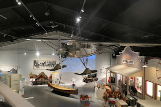
The museum itself features exhibits of all forms of transportation through the history of the Yukon Territory. Displays include the full-size replica of the Queen of the Yukon Ryan monoplane, sister to Lindbergh’s Spirit of St. Louis; railway rolling stock; Alaska Highway vintage vehicles; dogsleds, and stagecoaches. A very interesting story of survivors of a small plane crash is a feature that was amazing to read. You can read that story here.
Yukon Beringia Interpretive Center traces the Ice Age in northern and central Yukon, which, unlike the rest of Canada, was ice-free. The Blue Fish Caves near Old Crow reputedly hold the earliest evidence of humans in North America. Displays at the Center present the science and myth of the Ice Age subcontinent of Beringia, inhabited by extinct species such as woolly mammoths and giant short-faced bears, not to mention giant beavers – for real! – that stood over 6 feet tall. There is an 18-minute video presentation that is very interesting, a short, guided tour explaining some of the exhibits in the museum, and then a hands-on demonstration of throwing the atlatl, a spear used for hunting.
SS Klondike was the name of two sternwheelers, the second now a national historic site located in Whitehorse, Yukon, Canada. They ran freight between Whitehorse and Dawson City along the Yukon River, the first from 1929 to 1936 and the second, an almost exact replica of the first, from 1937 to 1950.
Since arriving in Canada, I’ve been seeing local eateries that advertise something called a “donaire.” I finally decided Whitehorse was my opportunity to try this local fare. We went for lunch at Great Bear Donaire as it had good reviews. It was very good. It’s something akin to a gyro, but with seasoned beef rather than lamb. I did enjoy the signs in the seating area.
Day Six: Whitehorse to Haines Junction: From Whitehorse to
Tok, Alaska, is approximately 400 miles. Unfortunately, we’ve been hearing
through the travelers’ grapevine that it’s a pretty tough section of highway.
We decided to split the drive into 3 chunks. I can only take so much teeth
rattling in one day. The first section is only 98 miles and was relatively
fine. A couple of gravel sections, and one construction area that we had a
pilot car lead us through. Haines Junction is a small, small town, but
encircled by mountains and is quite pretty.
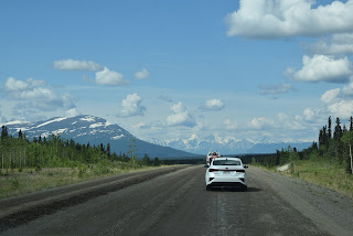
Day Seven: Haines Junction to Beaver Creek: Road was still not
hideous, but there were a few sections of gravel, more frost heaves, and pothole
areas. You really have to be looking ahead to anticipate the best part of the
road to use. Sometimes it was the other lane, which is fortunately pretty easy
to use and the traffic is very spread out. We very rarely have any line of
vehicles around us. We also do an average speed of 40-50 mph tops, much slower
in the bumpy spots It’s very pretty scenery. Much of the drive of 150 miles was
along Kluane Lake (Klu-wan-ee), designated a national park of Canada. As we
continued driving northwest, we moved into the Kluane Range of mountains to the
southwest, and the St. Elias mountains were visible in the distance. The highest
peaks in Canada, ranging from 19,545 feet to many in the over-15,000-foot range
are found in the St. Elias mountain range.
Our campground for the night, Discovery Yukon Lodgings, is
very nice but definitely off-grid. No cell service, no Wi-Fi. They generate
their own electricity. It’s very quiet! We got rested up for what has been promised as the most bone-jarring drive yet, and it did not disappoint in this respect. It is 143 miles from our campsite to Tok, Alaska, and it took us approximately 5 hours to do, with two bathroom stops and the photo op at the Welcome to Alaska sign. So I would say 4 1/2 hours. Truth be told, we're glad we had heard from prior travelers about the road conditions: forewarned is forearmed. Plus, it had been built up to be so absolutely horrendous that it actually turned out to be better than we had thought! Mind you, it's still awful, but it wasn't the nonstop weaving around potholes that we were expecting.
So we've arrived in Alaska after 5 years plus of planning, 2 years of COVID-caused postponements, and two months since leaving Florida. I actually feel like we've really made it and now the adventures can begin. After restocking some groceries here in Tok - we could not bring any poultry products, including eggs, or citrus fruits across the border, so we ate it all! - doing laundry, and refueling - diesel is $6.05/gallon here - it's time to move on down the road - leaving the Alaska Highway now and heading south on the Glenn Highway - towards Copper Center and Valdez where we have fishing and other activities planned. Stay tuned!


.JPG)


.JPG)
.JPG)


.JPG)
.JPG)

.JPG)


